
africa
-

How did the sand get into the Sahara Region?
When we consider a possibility that 300-400 years ago there was no sand in the Sahara region, then how did it get there? 400 year old Sahara Desert, or why people forgot everything they knew about Africa Annihilated African cities, killed population, establishment lies, Timgad and the Richat...- KorbenDallas
- Article
- africa sahara
- Replies: 27
- Section: Africa
-
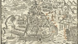
1541 Conquest of Tunis
The only known example of Matteo Pagano's Map of the 1541 Conquest of Tunis, engraved in Venice by the master engraver Matteo Pagano. The 1541 Algiers expedition occurred when Charles V of the Holy Roman Empire attempted to lead an amphibious attack against the Ottoman Empire's stronghold of...- KorbenDallas
- Media item
- 1541 africa tunis
- Comments: 0
- Category: Africa
-
Hydrophilacium Subterranean Pools: South America and Africa
Stumbled into a couple of older maps showing "hydrophilaciums". I am not sure what the exact meaning of the word is. Probably something like an underground water basin. Web translators were not really helpful. The African map had the below description. Africa. Kircher’s Mundus subterraneus...- KorbenDallas
- Article
- africa aquifer hydrophilacium south america
- Replies: 9
- Section: Known Parts of the World
-
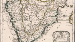
1656 Africa. Empires of Monomotapa and Monoemugi
Copper engraved double page map of southern part of Africa, hand colored in outline, with decorative cartouche. Showing political and administrative boundaries, major cities, villages, landmarks, rivers, mountains, drainage, etc. Relief shown pictorially.- KorbenDallas
- Media item
- africa map
- Comments: 0
- Category: Africa
-
Was previous Jerusalem located in England?
Wanted to post this prior to flying out to Florida. The other day I stumbled into two lines of 1661 text about the "old Jerusalem". I'm pretty sure you will be able to figure out what two lines I'm talking about once you get to them. Meanwhile, let's start with the Skull Hill: Golgotha...- KorbenDallas
- Article
- africa christ england israel jerusalem jesus
- Replies: 23
- Section: Europe
-
Did Monomotapa City become South African Pretoria City?
I was always wondering why a city in South Africa would be named Pretoria. The interest is somewhat self-explanatory. Praetor was a title granted by the government of Ancient Rome to men acting in one of two official capacities: the commander of an army; or, an elected magistrate, assigned...- KorbenDallas
- Article
- africa monomotapa pretoria
- Replies: 2
- Section: Africa
-
He says the Eye of Africa is the lost city of Atlantis
Ran into this video by a pretty popular YouTube personality. He thinks that the lost city of Atlantis is the Eye of Africa a.k.a. Richat Structure. Below is the video and the description provided with the video. Eye of Africa on the map Related threads: 400 year old Sahara Desert, or...- KorbenDallas
- Article
- africa atlantis richat
- Replies: 0
- Section: Atlantis
-
Annihilated African cities, killed population, establishment lies, Timgad and the Richat Structure Atlantis
It's hard to stay silent, when such a tremendous loss of life is accompanied by the establishment lies of unprecedented magnitude. I'm talking about Africa again. This thread is a sort of buildup on the already existing thread: 400 year old Sahara Desert, or why people forgot everything they...- KorbenDallas
- Article
- africa atlantis eye of africa richat sahara timgad
- Replies: 5
- Section: Africa
-
400 year old Sahara Desert, or why people forgot everything they knew about Africa
"All right, Beatrice, there was no alien. The flash of light you saw in the sky was not a UFO. Swamp gas from a weather balloon was trapped in a thermal pocket and reflected the light from Venus." - Kay, MIB. I always thought that Sahara Desert was thousands of years old. Of course, the...- KorbenDallas
- Article
- africa eye of africa richat sahara
- Replies: 18
- Section: Africa