I was always wondering why a city in South Africa would be named Pretoria. The interest is somewhat self-explanatory.

Somehow, I thought there was a connection there. Well, I got schooled by the narrative, and the reason it is called Pretoria goes like this:

Kind of discouraging it was, but a little bit of Andries Pretorius's bio allowed me to keep on going in my search.

In reality, the entire Johannesburg area presents the exact same interest, and once we get to the older maps you will understand why. As you can see, we have this nice little place called Centurion. I'm not sure when it received its name, but this infatuation with Ancient Rome is just bizarre.
Ancient Rome, for a second, was separated from this region of South Africa by 5,000 miles and 1,500 years. Why did they like it so much?
Pretoria is situated approximately 55 km (34 mi) north-northeast of Johannesburg in the northeast of South Africa, in a transitional belt between the plateau of the Highveld to the south and the lower-lying Bushveld to the north. It lies at an altitude of about 1,339 m (4,393 ft) above sea level, in a warm, sheltered, fertile valley, surrounded by the hills of the Magaliesberg range.

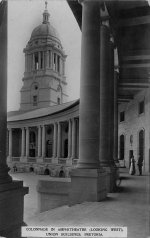
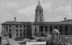
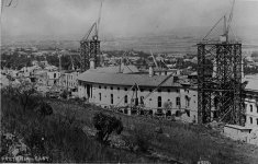
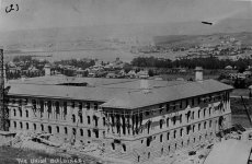
Architecture of PretoriaThis structure below is called the Union Buildings. Allegedly completed in 1913. The below image is dated with 1920. I simply do not believe that what we are seeing was only 7 years old at the time the photographs were taken. Additionally, the entire construction story sounds rather interesting.

The Union Buildings story goes like this:

Early Sketch

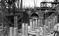
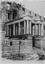
At the same time, we do have some construction, and near construction photos. Judge for yourself whether there is anything of importance there. Looks like the structure is being built, at the same time the quality of this scaffolding below looks strange.
Some easy side by side map comparison will place our Pretoria, and Johannesburg right on the spot. The reason I think Pretoria better matches this City of Monomotapa is simple. Pretoria is the capital, so, naturally, a Ville Royale of sorts. Somehow, I think our founder, Mr. Pretoreus knew that.
Once you look for the current terrain features of the former rivers in the area, you will see how perfectly this MONO-city matches Pretoria/Johannesburg. There are multiple maps you can reference. Here is a link for your convenience:

Then, as you can see, something happens prior to 1769, and the entire Empire of Monomotapa got moved to our contemporary Zimbabwe, and Mozambique.
What's interesting, as far as Mozambique goes (a bit off topic here) is this:
The former Monomotapa area became a desert populated by some savages. Whether the entire Empire of M. picked up, and moved North-West, or this is just the beginning of map re-adjustments to fit the narrative, I don't know. But the result of it, the contemporary historians are placing Monomotapa in Zimbabwe, which is only partially correct.
Wondering what happened there... could these "meteorite" craters have had something to do with this?

Saudi Arabia craters are not included in the image
Monomotapa, outlined by the green line, was a serious Empire. Well, at least it appears that way. A few cities they had as well.
Now, if you don't look for stuff, you can't be wrong. But looking at the older maps it's easy to see that back in the day there was a region, and a Royal City (Ville Royale) called MONOMOTAPA. Here is some narrative:

Meanwhile, some time prior to 1522 this Monomotapa region was ruled by this caucasian looking King - Hengi Zedaici. The linked books are in French. So, whoever wants to volunteer to translate, thank you very much.
KD: Back to the Pretorius family. Could they be sent to where Monomotapa-city once stood, to fulfill their "ancient" duties of Praetors, while simultaneously fishing for the recently buried reaches of the Ville Royalle?
- Praetor was a title granted by the government of Ancient Rome to men acting in one of two official capacities: the commander of an army; or, an elected magistrate, assigned various duties.
Somehow, I thought there was a connection there. Well, I got schooled by the narrative, and the reason it is called Pretoria goes like this:
- Pretoria was founded in 1855 by Marthinus Pretorius, a leader of the Voortrekkers, who named it after his father Andries Pretorius and chose a spot on the banks of the "Monkeys river" to be the new capital of the South African Republic. The elder Pretorius had become a national hero of the Voortrekkers after his victory over Dingane and the Zulus in the Battle of Blood River. The elder Pretorius also negotiated the Sand River Convention (1852), in which the UK acknowledged the independence of the Transvaal. It became the capital of the South African Republic (ZAR) on 1 May 1860.
- Pretorius descended from the line of the earliest Dutch settlers in the Cape Colony. He belonged to the fifth generation of the progenitor, Johannes Pretorius son of Reverend Wessel Schulte of the Netherlands. Schulte in his time as a theology student at the University of Leiden changed his name to the Latin form and therefore became Wesselius Praetorius (later Pretorius).
- Schulte in his time as a theology student at the University of Leiden changed his name to the Latin form and therefore became Wesselius Praetorius (later Pretorius).
- Recorded in several forms (including Praetor, Praetorius, Pratorius, Pretorius, (German), and in English Preater, Preter and Pretor), Pretorius is a surname of Germanic origins, although the ultimate origin is the Roman word "praetor". This literally meant "leader", but was used in Imperial Rome to describe officials who led processions, as well as the Praetorian Guard, who provided the security for the Senate and the Imperial Roman family. Although apparently first recorded in England several centuries before Germany, which is probably because of lost medieval records, it is rare in England, although now found in some numbers in Austria, Switzerland and South Africa.
- LOL, these "probably" and "apparently" will never cease to amaze me.
- The name Schulte comes from one of those ancient dukedoms, territories and states that would eventually form a part of present day Germany. At its birth in the Middle Ages, it was used to indicate someone who worked as a town-mayor derived from the medieval name "Schultheis" which has the same meaning.
- In Ancient Rome a praetor was attended by six lictors.
Ancient Rome, for a second, was separated from this region of South Africa by 5,000 miles and 1,500 years. Why did they like it so much?
Pretoria is situated approximately 55 km (34 mi) north-northeast of Johannesburg in the northeast of South Africa, in a transitional belt between the plateau of the Highveld to the south and the lower-lying Bushveld to the north. It lies at an altitude of about 1,339 m (4,393 ft) above sea level, in a warm, sheltered, fertile valley, surrounded by the hills of the Magaliesberg range.
Architecture of Pretoria
- In 1909 Herbert Baker was commissioned to design the Government Building of the Union of South Africa (which was formed on 31 May 1910) in Pretoria. Pretoria was to become the administrative centre for the new government. In November 1910 the cornerstone of the Union Building was laid.
- Lord Selborne and H.C. Hull, a member of the first Union Cabinet, chose Meintjieskop as the site for Baker's design. The site was that of a disused quarry and the existing excavations were used to create the amphitheatre, which was set about with ornamental pools, fountains, sculptures, balustrades and trees.
- The design consisted of two identical wings, joined by a semicircular colonnade forming the backdrop of the amphitheatre. The colonnade was terminated on either side by a tower. Each wing had a basement and three floors above ground. The interiors were created in the Cape Dutch style with carved teak fanlights, heavy doors, dark ceiling beams contrasting with white plaster walls and heavy wood furniture. Baker used indigenous materials as far as possible. The granite was quarried on site while Buiskop sandstone was used for the courtyards. Stinkwood and Rhodesian teak were used for timber and wood panelling. The roof tiles and quarry tiles for the floors were made in Vereeniging.
- The cornerstone was laid in November 1910, shortly after the Union of South Africa – for which the buildings are named – was formed. Taking 1,265 workers over three years to build, the structure was completed in 1913 at a total cost of £1,310,640 for the building and £350,000 for the site.
- Designed by Sir Herbert Baker in 1908, building began in 1909 and was completed in 1913. It took approximately 1265 artisans, workmen and labourers almost three years to construct, using 14 million bricks for the interior office walls, half a million cubic feet of freestone, 74 000 cubic yards of concrete, 40 000 bags of cement and 20 000 cubic feet of granite.
Early Sketch
Then we have a whole group of buildings which make me question the photography invention time frame.Palace of Justice

Palace of Justice, Pretoria - Wikipedia
Old Government Building

Ou Raadsaal - Wikipedia + Inside
Pretoria Boys High School

Pretoria Boys High School - Wikipedia
Church Square, 1899

Voortrekker Monument

Post Office

Anyways, there were, and still are tons of these buildings in Pretoria, and even more in Johannesburg.Palace of Justice, Pretoria - Wikipedia
Old Government Building
Ou Raadsaal - Wikipedia + Inside
Pretoria Boys High School
Pretoria Boys High School - Wikipedia
Church Square, 1899
Voortrekker Monument
Post Office
Monomotapa

A little description of the great world


1616 Relations, of the Most Famous Kingdoms
and Commonweales Thorough the World
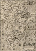
Rare English map of Southern Africa, published by Jonas Moore in London. The map appeared in Moore's A New Geography. Many of the plates in the work were engraved by Herman Moll, who had moved to London in 1678 and had not yet begun publishing under his own name. These are among the earliest known maps engraved by Moll. Burden credits Moll's first map as being his work for William Berry, also in 1681.A little description of the great world
1616 Relations, of the Most Famous Kingdoms
and Commonweales Thorough the World
Some easy side by side map comparison will place our Pretoria, and Johannesburg right on the spot. The reason I think Pretoria better matches this City of Monomotapa is simple. Pretoria is the capital, so, naturally, a Ville Royale of sorts. Somehow, I think our founder, Mr. Pretoreus knew that.
Once you look for the current terrain features of the former rivers in the area, you will see how perfectly this MONO-city matches Pretoria/Johannesburg. There are multiple maps you can reference. Here is a link for your convenience:
What's interesting, as far as Mozambique goes (a bit off topic here) is this:
- The Somali merchants from Mogadishu, the capital of the Ajuran Empire, established a colony in Mozambique to extract gold from the mines in Sofala.
- In 1505 the Portuguese were granted permission to erect a factory and fortress at Sofala.
1572

The former Monomotapa area became a desert populated by some savages. Whether the entire Empire of M. picked up, and moved North-West, or this is just the beginning of map re-adjustments to fit the narrative, I don't know. But the result of it, the contemporary historians are placing Monomotapa in Zimbabwe, which is only partially correct.
Wondering what happened there... could these "meteorite" craters have had something to do with this?
Saudi Arabia craters are not included in the image
Monomotapa, outlined by the green line, was a serious Empire. Well, at least it appears that way. A few cities they had as well.
Now, if you don't look for stuff, you can't be wrong. But looking at the older maps it's easy to see that back in the day there was a region, and a Royal City (Ville Royale) called MONOMOTAPA. Here is some narrative:
- In old maps of south-east Africa, derived originally from Portuguese and from Dutch sources, an extensive region on the Cuama or Zambezi and to the south of it is styled regnum monomotapae.The precise character of the kingdom or empire to which allusion is made has been the subject of much discussion, and some modern historians have gone so far as to relegate the monomotapa to the realm of myth. But such scepticism is unjustifiable in view of the perfect unanimity with which, in spite of variations of detail, all Portuguese writers from the beginning of the 16th century onwards reiterated the assertion that there was a powerful rule known far and wide by that title.
- The word "monomotapa " is of Bantu origin and has been variously interpreted. Father J. Torrend, Comparative Grammar of the South African Bantu Languages (p. Ioi) renders it " Lord of the water-elephants," and remarks that the hippopotamus is even to the present day a sacred animal among the Karanga. The earliest recorded bearer .of the name is Mokomba Menamotapam, mentioned by Diogo de Alcacova in 1506 as father of the Kwesarimgo Menamotapam who ruled at that date over Vealanga, a large kingdom that included Sofala. His capital was called Zumubany, an obvious corruption of the term " Zimbabwe," regularly used to describe the residence of any important chief. The title is still found during the 18th century, but had probably become extinct by the beginning of the 19th if not earlier. Possibly its use was not confined to a single tribal section, occurring as it does in conjunction with the distinct dynastic names of Mokomba and Mambo, but the Karanga is the only tribe to which the Portuguese chroniclers attribute it. The latter, indeed, not only refer to the territory and the people of the monomotapa as " Mocaranga " (i.e. of the Karanga tribe), but explicitly assert that the " emperor " himself was a " Mocaranga." Consequently, he must have been a negro, and the Dominican who records the baptism of Dom Filippe by a friar of the order in the middle of the 17th century actually states that this " powerful king " was a black man (`; corn as carnes pretas "). This alone would be sufficient to controvert the baseless assumption that there existed in southern Rhodesia a ruling caste of different racial origin from the general Bantu population. The events following on the murder of the Jesuit father Dom Gongalo da Silveira (cf. Lusiads X. 93) sufficiently demonstrate that the monomotapa, though susceptible to the persuasion of foreigners, was an independent potentate in the 16th century. The state and ceremony of his court, the number of his wives, and the order and organization of his officials, are described by several of the chroniclers.
- It is difficult to arrive at an estimate of the extent of territory over which this great negro chief exercised direct or indirect control. The most extravagant theory is naturally that which was expressed by the Portuguese advocates in connexion with the dispute as to the ownership of Delagoa Bay. The crown of Portugal based its case against England on the cession of territory contained in a well-known treaty with the monomotapa (1629), and stated that this monarch's dominions then extended nearly to the Cape of Good Hope. A more moderate and usual view is given by Diego de Couto, who in 1616 speaks of " a dominion over all Kaffraria from the Cabo das Correntes to the great river Zambezi." Several 17th-century writers extend the " empire " to the north of the Zambezi, Bocarro giving it in all " a circumference of more than three hundred leagues." It was " divided among petty kings and other lords with fewer vassals who are called inkosis or fumes." According to these authors, however, including Dos Santos, the paramountcy of the monomotapa was impaired in the 17th century by a series of rebellions. His zimbabwe, wherever it may have been in earlier days, was now;fixed near the Portuguese fort of Masapa, only a short distance south of the Zambezi. A Portuguese garrison was maintained in it, and the monarch himself from the year 1607 onwards was little more than a puppet who was generally baptized by the Dominicans with a Portuguese name.
Meanwhile, some time prior to 1522 this Monomotapa region was ruled by this caucasian looking King - Hengi Zedaici. The linked books are in French. So, whoever wants to volunteer to translate, thank you very much.
KD: Back to the Pretorius family. Could they be sent to where Monomotapa-city once stood, to fulfill their "ancient" duties of Praetors, while simultaneously fishing for the recently buried reaches of the Ville Royalle?
- I do think the world was global, and stuff was more or less similar all over. Same civilization was building similar structures relatively at the same time, using the similar technology. In some places we attribute the structures to the Ancient Rome, and Greece. In other places our historical narrative placed the structures much closer to today's date. I think South Africa, including Pretoria/Johannesburg could be one of such places.
- Would be nice if someone did some research into the 16th -17th century Portuguese Maps covering this area. Sounds like there could be quite a few reasons to research it, with gold being just one of those.


