It's hard to stay silent, when such a tremendous loss of life is accompanied by the establishment lies of unprecedented magnitude. I'm talking about Africa again. This thread is a sort of buildup on the already existing thread: 400 year old Sahara Desert, or why people forgot everything they knew about Africa. Influenced by the recent publicity related to the ancient lost city of Atlantis being located in Africa, I took a hard look at quite a few of the older maps. Based on what I've seen, I did not see any evidence pointing to the African Atlantis being located on top of the Richat "Eye of Africa" structure. What I did see though, was the destruction of the majority of the African continent, together with its cities, as well as with its inhabitants.
Note: As you read the below, it is important to understand, that year 1570 people knew way more about 1570 than we do today. Same goes for people who lived in 1645, 1716, 1802 or any other time in history. They were the witnesses, and not us. Naturally, if you buy the bogus narrative compliant explanation of the cartographers of the past making stuff up, this thread is not for you.
Officially, the exploration of Africa was supposed to be happening in the 19th century. The below two map compilation is meant to illustrate the problem we are presented with. It also illustrates the lies we are being deliberately fed. The lies which have become a part of our every day lives.
The official description for the below 1802 map states the following:
All we know about him: Aaron Arrowsmith (1750–1823), migrated to London from Winston in Durham when about twenty years of age, and was employed by John Cary, the engraver. In 1790 he made himself famous by his large chart of the world on Mercator’s projection. Four years later he published another large map of the world on the globular projection, with a companion volume of explanation. The maps of North America (1796) and Scotland (1807) are the most celebrated of his many later productions. He left two sons, Aaron and Samuel, the elder of whom was the compiler of the Eton Comparative Atlas, of a Biblical atlas, and of various manuals of geography. They carried on the business in company with John Arrowsmith (1790–1873), nephew of the elder Aaron. In 1834 John published his London Atlas, the best set of maps then in existence. He followed up the atlas with a long series of elaborate and carefully executed maps, those of Australia, America, Africa and India being especially valuable. In 1863 he received the gold medal of the Royal Geographical Society, of which body he was one of the founders.
The above 1570 Africae Tabula Nova map is, by far, not the only "older" map out there. We can fast forward 120 years to 1690, and see the same picture of Africa. Please feel free to browse through maps of Africa, and verify for yourself. This here was just a short synopsis. For the straight up Sahara Desert related story pease visit the below thread:
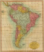
KD: And let us be real for a second. Africa was not some distant, and recently re-discovered North or South America. In 1802 scientific society suddenly realized that their knowledge of the neighboring Africa equaled one big fat zero? Did they really discovered 150 miles x 180 miles Lake Victoria in 1858? Checkout below what we knew in 1812 about South America. How much sense does any of this make?
The below red highlighted city symbols appear rather insignificant on some 400 year old maps. Yet, all of those places were populated cities, and their insignificance could be a false assumption. They were occupied by living and breathing human beings. Later on you will see why this notion is important.
In the above 1635 map cutout we can see two very familiar names, which are Cairo and Alexandria (the third, Algiers, is not on the cutout, but it is on the linked map). They sit next to a little city symbol similar to the one below.

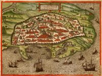
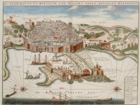
Behind each and every one of those tiny highlighted city symbols, there was a city. Let's take a look at some of the cities marked by these city symbols. I chose Cairo, Alexandria, and Algiers, because we know that these cities existed, and still do.
According to the official version, the cities I'm gonna be talking about later on never existed, and reflected on some ancient cartographers imagination (or incompetency).
If you follow this Google search link, you will be able to see other various 16th century city plans (not necessarily Africa related) marked with the same "city" symbol on various maps. The below population numbers are meant to demonstrate the capacity of those cities. Meaning how many people they could allegedly fit within their walls.
Cairo population - link:
Kasbah of Algiers citadel alone used to have 150 tiled public water fountains. Today, only six of those remain.
Make sure you read the following 1902 Munsey's Magazine article. You might get surprised what this Roman retirement city for veterans had to offer.


---


---


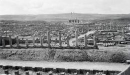
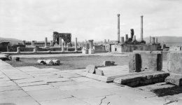
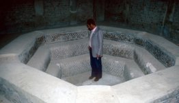
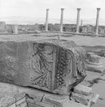
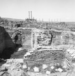
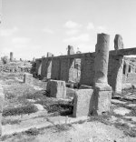
Now check out some of the below pictures, and try to imagine this city when it was thriving. Be honest, how much time would it take us to build such a city today?
KD: I simply used Timgad as an example of the destroyed/missing cities this article is essentially about. I honestly doubt that the real name of this city had anything to do with Timgad, or Thamugas. The info about this city magically popped up in 1870s, for all of the survived places have to have their own history. I think this Timgad could be the city of Canatudi on this 1635 map.
It appears that Timgad was on the outskirts of the cataclysm which produced the Sahara Desert, and altered geographical features of the other African areas. As an example I could name the emergence of Lakes Victoria, Tanganyika, and Malawi.
I think this catastrophic event happened around 1666. I could care less for the weirdness of the number, but this African event appears to coincide with the formation of the Santorini Archipelago, which, in my opinion, took place around 1666.
Was this cataclysm man made, or natural? I have no clue. May be these people do.
Missing Cities/TownsEssentially, if the maps in question contain real cities like Cairo, Alexandria and Algiers, I find no real reason to question past existence of the other cities, or towns present on the same maps. And considering that those "imaginary" cities were marked on multiple maps with the same "city" symbol, I will consider them comparable in size.

Now, when we fully understand that behind each one of the above symbols could be 10,000, or 50,000, or 250,000, or 400,000, or whatever number of people, let us take a look at the below map comparison.
Now I have a few simple questions. Where did all these cities, and towns go? Not some bamboo huts Wikipedia suggests for a couple of the names, but actual cities, and towns... what happened to them? Cities like the ones in this little passage kindly produced by Google: Doldel, Augesa, Gebaghe. Where is the Lake Sachaf?

I was able to find this German book dated 1708. I have no idea what it says, but here are the pages. If our German speakers could help out, would be awesome. 1708 is well into the fake history pubs territory, but at least this book has the names of the above cities.
Also, who was this Rönigreich Damut?


For those enjoying mainstream geographical explanations, here is a 1891 article explaining that 16th century cartographers were dumb, and excessively creative with their maps: Scottish Geographical Magazine.
KD: obvously the above several cities I picked are a drop in the bucket. How many cities, and towns ceased to exist? Looks like hundreds did.
In my opinion the ancient city of Hoden was much bigger than today's Ouadane, located 5 miles south-west from the outer rim of the Richat structure. I have this feeling that the majority of the older Hoden did not quite survive the arrival of the Richat Structure. If you look at these pictures of Ouadane, you may see a few interesting ones.


CratersI think some type of a weapon could have been used. I have no idea what it could have been (if it was used, where it came from, etc), but we have this interesting dependency between crater locations, and the mapped African deserts. In my opinion, it happened a few hundred years ago.

Saudi Arabia craters are not included on the imageOf course, scientists are saying that it happened millions of years ago. They even know how to differentiate between a 3 mln year old, and a 575 mln year old crater. I think they are full of it, but that is just my opinion on the issue. By pushing these terrible events millions of years back, they created moral comfort on Earth. May be it's a good thing, and may be it is not a good thing.
Maps for your review:
KD summary: I do think that millions, or tens of millions, or hundreds of millions of people (may be some additional humanoid species too) were killed by this enormous event. In my opinion it happened between approximately 400-500 years ago. The truth is being hidden from public knowledge. That's it. I really have nothing else to add.
Note: As you read the below, it is important to understand, that year 1570 people knew way more about 1570 than we do today. Same goes for people who lived in 1645, 1716, 1802 or any other time in history. They were the witnesses, and not us. Naturally, if you buy the bogus narrative compliant explanation of the cartographers of the past making stuff up, this thread is not for you.
Sahara Desert
... and its fake history ...
Wikipedia says, "During the last glacial period, the Sahara was much larger than it is today, extending south beyond its current boundaries. The end of the glacial period brought more rain to the Sahara, from about 8000 BC to 6000 BC, perhaps because of low pressure areas over the collapsing ice sheets to the north. Once the ice sheets were gone, the northern Sahara dried out. In the southern Sahara, the drying trend was initially counteracted by the monsoon, which brought rain further north than it does today. By around 4200 BC, however, the monsoon retreated south to approximately where it is today, leading to the gradual desertification of the Sahara. The Sahara is now as dry as it was about 13,000 years ago."... and its fake history ...
Officially, the exploration of Africa was supposed to be happening in the 19th century. The below two map compilation is meant to illustrate the problem we are presented with. It also illustrates the lies we are being deliberately fed. The lies which have become a part of our every day lives.
The official description for the below 1802 map states the following:
- One of the first maps of Africa to show the true state of geographical knowledge of the continent, hence the vast areas of the map with no information - this was Arrowsmith's style when he mapped Africa, the America's and other parts of the world where geographic information was both unknown and evolving. Aaron Arrowsmith simply stripped away centuries of accumulated myth, misconception and unsustainable guesswork, and took the mapping of Africa back to the bare bones of substantiated fact, leaving the interior as a blank canvas, a challenge to a new generation of explorers. As a picture, many of his predecessors of a century earlier would not have thought of publishing it, as a statement of intent it raised the standard for geographical accuracy above that practiced by the vast majority of his contemporaries" .
All we know about him: Aaron Arrowsmith (1750–1823), migrated to London from Winston in Durham when about twenty years of age, and was employed by John Cary, the engraver. In 1790 he made himself famous by his large chart of the world on Mercator’s projection. Four years later he published another large map of the world on the globular projection, with a companion volume of explanation. The maps of North America (1796) and Scotland (1807) are the most celebrated of his many later productions. He left two sons, Aaron and Samuel, the elder of whom was the compiler of the Eton Comparative Atlas, of a Biblical atlas, and of various manuals of geography. They carried on the business in company with John Arrowsmith (1790–1873), nephew of the elder Aaron. In 1834 John published his London Atlas, the best set of maps then in existence. He followed up the atlas with a long series of elaborate and carefully executed maps, those of Australia, America, Africa and India being especially valuable. In 1863 he received the gold medal of the Royal Geographical Society, of which body he was one of the founders.
The above 1570 Africae Tabula Nova map is, by far, not the only "older" map out there. We can fast forward 120 years to 1690, and see the same picture of Africa. Please feel free to browse through maps of Africa, and verify for yourself. This here was just a short synopsis. For the straight up Sahara Desert related story pease visit the below thread:
KD: And let us be real for a second. Africa was not some distant, and recently re-discovered North or South America. In 1802 scientific society suddenly realized that their knowledge of the neighboring Africa equaled one big fat zero? Did they really discovered 150 miles x 180 miles Lake Victoria in 1858? Checkout below what we knew in 1812 about South America. How much sense does any of this make?
The below red highlighted city symbols appear rather insignificant on some 400 year old maps. Yet, all of those places were populated cities, and their insignificance could be a false assumption. They were occupied by living and breathing human beings. Later on you will see why this notion is important.
In the above 1635 map cutout we can see two very familiar names, which are Cairo and Alexandria (the third, Algiers, is not on the cutout, but it is on the linked map). They sit next to a little city symbol similar to the one below.
According to the official version, the cities I'm gonna be talking about later on never existed, and reflected on some ancient cartographers imagination (or incompetency).
If you follow this Google search link, you will be able to see other various 16th century city plans (not necessarily Africa related) marked with the same "city" symbol on various maps. The below population numbers are meant to demonstrate the capacity of those cities. Meaning how many people they could allegedly fit within their walls.
Cairo population - link:
- 1400: 125,000 - 260,000
- 1500: 400,000
- 1575: 275,000
- 700: 216,000
- 900: 175,000
- 1800: 8,000
- 1840: 60,000
Kasbah of Algiers citadel alone used to have 150 tiled public water fountains. Today, only six of those remain.
- 1600: 100,000 with 30,000 additional Christian captives
- 1881: 65,227
TIMGAD

Here is an example of the strangeness we are so used to, we consider it normal. The below ruins belong to the city of Timgad, Algeria. Of course, it is a UNESCO World Heritage Site. Which means no digging, no touching, and no nothing. What if something unwanted gets discovered? Follows is a short story of Timgard:
- The city was founded ex nihilo as a military colony by the emperor Trajan around AD 100.
- KD: ex nihilo means "something coming from nothing". City which came from nowhere?
- It was originally populated largely by Roman veterans .
- In the 5th century, the city was sacked by the Vandals before falling into decline.
- In AD 535, the Byzantine general Solomon found the city empty when he came to occupy it.
- In the following century, the city was briefly repopulated as a primarily Christian city before being sacked by Berbers in the 5th century.
- Timgad was destroyed at the end of the 5th century by montagnards of the Aurès.
- The Byzantine Reconquest revived some activities in the city, defended by a fortress built to the south, in 539, reusing blocks removed from Roman monuments.
- The Arab invasion brought about the final ruin of Thamugadi which ceased to be inhabited after the 8th century.
- Because no new settlements were founded on the site after the 7th century, the city was partially preserved under sand up to a depth of approximately one meter.
Make sure you read the following 1902 Munsey's Magazine article. You might get surprised what this Roman retirement city for veterans had to offer.
---
---
KD: I simply used Timgad as an example of the destroyed/missing cities this article is essentially about. I honestly doubt that the real name of this city had anything to do with Timgad, or Thamugas. The info about this city magically popped up in 1870s, for all of the survived places have to have their own history. I think this Timgad could be the city of Canatudi on this 1635 map.
It appears that Timgad was on the outskirts of the cataclysm which produced the Sahara Desert, and altered geographical features of the other African areas. As an example I could name the emergence of Lakes Victoria, Tanganyika, and Malawi.
I think this catastrophic event happened around 1666. I could care less for the weirdness of the number, but this African event appears to coincide with the formation of the Santorini Archipelago, which, in my opinion, took place around 1666.
Was this cataclysm man made, or natural? I have no clue. May be these people do.
Missing Cities/Towns
Now I have a few simple questions. Where did all these cities, and towns go? Not some bamboo huts Wikipedia suggests for a couple of the names, but actual cities, and towns... what happened to them? Cities like the ones in this little passage kindly produced by Google: Doldel, Augesa, Gebaghe. Where is the Lake Sachaf?
Also, who was this Rönigreich Damut?
For those enjoying mainstream geographical explanations, here is a 1891 article explaining that 16th century cartographers were dumb, and excessively creative with their maps: Scottish Geographical Magazine.
KD: obvously the above several cities I picked are a drop in the bucket. How many cities, and towns ceased to exist? Looks like hundreds did.
The Richat Atlantis

Such a possibility is being mentioned here. I think finding Atlantis would be super cool, but I have my doubts that the Richat Structure has anything to do with it. Maps suggest that there was no Sahara Desert a few hundred years ago. In my opinion the Eye of Sahara emerged simultaneously with all the Sahara Desert. In other words, Sahara would have to be thousands of years old for any possibility for the Richat Structure to be Atlantis. As it stands, I think the Eye of Sahara is some sort of a weaponry related crater.
In my opinion the ancient city of Hoden was much bigger than today's Ouadane, located 5 miles south-west from the outer rim of the Richat structure. I have this feeling that the majority of the older Hoden did not quite survive the arrival of the Richat Structure. If you look at these pictures of Ouadane, you may see a few interesting ones.
Craters
Saudi Arabia craters are not included on the image
Maps for your review:
- 1570 - Africae Tabula Nova
- 1630 - Africae nova descriptio
- 1635 - Africae nova descriptio
- 1676 - Africae
- 1687 - A new map of Africa divided into kingdoms and provinces
- 1740 - Africae in Tabula Geographica Delineatio
- 1802 - Africa
- 1834 - Africa
- 1863 - Afrika
- + Various - African Maps by Year
- + Related - 400 year old Sahara Desert, or why people forgot everything they knew about Africa
KD summary: I do think that millions, or tens of millions, or hundreds of millions of people (may be some additional humanoid species too) were killed by this enormous event. In my opinion it happened between approximately 400-500 years ago. The truth is being hidden from public knowledge. That's it. I really have nothing else to add.


