This article was originally published on 2/2/2019.
While looking for the origins of Saint Patersburg, I came across this 1539 map called Carta Marina. After zooming in on Iceland, and googling some of the cities, I ran into another map called Da Islandia Insula, and attributed to 1566. Below are some of my observations. This is a reader's article, and requires paying attention to detail.
- Note: the maps below are not oriented North to South due to the older maps orientation.
Map Links:
- 1566 Da Islandia Insula - author unknown
- 1570 Da Islandia Insula - the first (?) map of Camocio
- 1574 Da Islandia Insula - the second map of Camocio
- 1500-1600 Maps of Iceland
- all additional sources and links are going to be at the bottom
- We have, at least, a couple of vanished cities, which are Saxa and Scalholdin.
- Also in the maps are contemporary looking buildings, with one being (arguably) six stories high.
- We have strange objects (resembling chimneys, or water towers) which appear to be the sources of several rivers.
- The maps contain "Cryptoporticus" passage ways.
- We also have a couple suspicious lakes.
- Chaos inscriptions and other things, etc.
- To tie all of this together - none of the above appears to exist any longer.
Da Islandia Insula by Incognito

The 1566 map of Iceland DA ISLANDIA INSULA has no known author. Web sources tell us, that it uses Carta Marina of Olaus Magnus as its model for Iceland, even if it is not obvious at a glance. If you flip the country over and turn it 90° right, you can see that it resembles Carta Marina´s Iceland. Camoccio published practically the same map under the same title in 1570 and 1574.
- Essentially, the author is unknown and the map is attributed to 1566. Weird how we have no clue where it came from, but we know that it was done in 1566.
Carta Marina by Olaus Magnus

In a nutshell, Mr. Magnus lived (allegedly, of course) between 1490 and 1557. The Carta Marina map was published in 1539. Its full name is Carta marina et descriptio septentrionalium terrarum, which translates to Marine map and description of the Northern lands.
Map Comparison
I am going to put Da Islandia Insula, and Carta Marina Iceland side by side with each other, and with the Google Map of Iceland. For right now, let us just see whether these two older maps are somewhat accurate as they pertain to today's outline of Iceland. Please make your own conclusion how representative of our contemporary Iceland these maps are.Da Islandia Insula vs Carta Marina

Da Islandia Insula vs Google Maps

Carta Marina vs Google Maps

It is probably hard to judge which map came first, for the 1566 explanation sounds like they do not really know. The two look fairly similar, but are not quite the same. The difference is primarily in the outline of the island, while the contents are very much the same. Whether one of the two is a poor copy of the other is unknown. The earliest date given to us by the official history is 1539 (for the Carta Marina). That's the date we are going to use.Da Islandia Insula vs Google Maps
Carta Marina vs Google Maps
Saxa and Scalholdin

Judging by what we see on the older maps, Saxa and Scalholdin appear like two major cities, or towns. At the same time, today's state of things suggests that they were not.
- Saxa from Icelandic means to chop, cut into pieces. The Old Norselanguage has a similar meaning.
- Saxa is no city any longer. May be it never was, I don't know. Today it's a Natural Phenomenon Geyser.
- Somehow, today's Saxa (unless I failed to spot another one) is located at a totally different place on the coast of Iceland. It also is a Natural Phenomenon Geyser.
- Saxa in pictures
- Scalholdin is allegedly today's Skálholt, but is it really? Below is the comparison of 1539 vs 2000s.
- Adam of Bremen, writing circa 1075, described Skálholt (Scaldholz) as the "largest city" in Iceland.
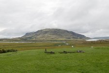
- Skálholt is a historical, cultural, and religious center on the river Hvítá near Laugarvatn in the south of Iceland. The town was an ecclesiastic power center – the ancient headquarters of Iceland’s bishops and the seat of culture, education, and worldly power for 700 years. It was one of the two bishoprics which, until the Reformation in 1540, governed the Icelandic people. The original cathedral was dismantled in the 18th century. The present church was built in 1963.
- The first Cathedral was built in the 12th century, and altogether there have been 10 churches here built of wood, some of them burnt down, others were destroyed by bad weather etc. Some of them were much larger than the present memorial Cathedral, which was built from 1956-1963.
- Thirty-two Catholic bishops sat here until the Reformation to Lutheranism in 1540. The Reformation was not done peacefully and the last Catholic bishop, Jón Arason at Hólar, and his two sons were beheaded here in 1550. After this tragic event, 13 Lutheran bishops sat here until 1801 when the see was moved to Reykjavík.
- Although many of the artefacts from the ancient churches of Skálholt are held in the National Museum in Reykjavik, the religious and general history of this town attracts visitors to it. For a start, the church has beautiful artwork and visitors can learn more about the interesting history of the place, including its executions and beheadings. Another attraction in this area is Snorri’s Pool at Reykholt, which is situated west of Borgarnes. The Viking historian and renowned writer, Snorri Sturluson, created many of his works at this place. He was assassinated here in 1241, during the early years of the saga age in Iceland, by Gissur Þorvaldsson, a political adversary. The Snorrstofa museum in the town is devoted to Sturluson. There is another monument to Sturluson called Snorralaug (which means Snorri’s pool) behind the town’s school. This is a round pool of about 4 meters (13 ft) in diameter, and behind it is a path, which is said to lead to the cellar where the famous writer was assassinated.
- Skálholt is arguably one of Iceland’s most historic sites. In addition to being the seat of bishops from 1056 until 1785, the country’s first school was also founded here in 1056. The effort to build the enormous cathedral in 1153 was considerable, with timbers being transported all the way from Norway. Its intriguing history alone merits a visit to Skálholt.
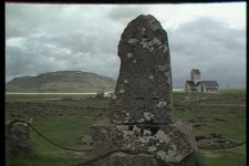
But when we search for the historical images of Scalholdin, we run into pages like this one: The historical Skálholt Episcopal See in South-Iceland. And this is where a total different picture gets painted.
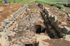
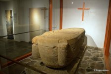
A sarcophagus was found in 1954 during the excavation for the foundations of the church, containing the remains of our bishop Páll Jónsson, who died in 1211. The sarcophagus is on display in the church crypt/cellar. The sarcophagus is by far the most important old relic to be found at Skálholt. In the crypt, you will also find 2 Icelandic tombstones and foreign tombstones of 5 bishops and 1 councillor.
Catch 22: Today's Skálholt is not really our Scalholdin. At least their respective locations on the map do not match.
KD: Today, Saxa is not a city or town, and located at a different place. Today's Skálholt is not our Scalholdin, and is also located at a different place.
- What else is new?
Scalholdin a.k.a. Reykjahlíð?
Yup, I think our Scalholdin was located where today's Reykjahlíð is. This photograph below represents the village of Reykjahlíð. It has approximately 300 inhabitants and is situated on the shores of Lake Mývatn in the North of Iceland.And Scalholdin was supposed to be the biggest city in Iceland back in the day. 300 inhabitants and no ruins hardly cut it.
- Bla-bla-bla: During the so-called Mývatn fires, caused by the eruption of the nearby volcano Krafla in 1729, the village was destroyed by a lava stream. However, the inhabitants were saved when the lava flow stopped in front of the village church on higher ground, allegedly as the result of the prayers of the village priest.
- From Reykjahlíð, it is possible to go to many sights in the area, most notably Krafla. The volcano last erupted in 1984, but the vapour of a warm lava field and of sulphur springs can still be seen. Not far from there is the crater Víti (meaning "hell" in Icelandic), but looking today rather harmless with a blue lake at its bottom. Its apparent tranquility belies the fact that its last eruption was as recent as 1976.
- Other interesting places are on the lake itself, like the volcano Hverfjall, the pseudo-craters of Skútusstaðir and Dimmuborgir (a strange lava formation).
- The name Mývatn is sometimes used not only for the lake but the whole surrounding inhabited area. The River Laxá, Lake Mývatn and the surrounding wetlands are protected as a nature reserve (the Mývatn-Laxá Nature Conservation Area, which occupies 4,400 km2 (440,000 ha).
- Ladies and Gentlemen, this is where they are hiding our stolen history. Digging is strictly prohibited, for we need to "preserve and conserve". If not protected, people will start discovering cities similar to Scalholdin and Saxa. Preserve and Conserve the lies that is.
Reykjahlíð
On the shores of Lake Mývatn
Traditional BS comes first: Mývatn is a shallow lake situated in an area of active volcanism in the north of Iceland, not far from Krafla volcano. The lake was created by a large basaltic lava eruption 2300 years ago, and the surrounding landscape is dominated by volcanic landforms, including lava pillars and pseudocraters.On the shores of Lake Mývatn
This is where the reader needs to get familiarized with my earlier articles, for this lake did not exist in 1539 (IMHO):
Wikipedia article pertaining to Lake Mývatn has 5 or 6 photographs in it. But they chose poorly, and possibly deliberately. Here are a few real photographs covering the area of Myvatn Lake, Iceland.
As a matter of fact, the entire Northeast of Iceland looks like the "laked" images below. What happened there?
Where is the real Scalholdin?
Rectangular Buildings
- May be these wavy lines are related to electricity through frequencies and vibrations. This is for someone else to hypothesize, and I'm just throwing this out here.
ICE: Water Towers & Lakes
I do not know what these water "towers" were supposed to be, (may be you have an idea). It appears we have river sources originating at the above four locations.
Hekla Volcano
- As we can see, Ortelius's Hekla is located under the icecap of the so-called Vatnajökull Mountains. Additionally Ortelius's Hekla still does not correspond to the one titled Mons Heclafiel (presented on this Da Islandia Insula map). Looks like Ortelius picked Mons Helgafiel and called it Hekla.
for larger images reference sources below
Cryptoporticus
Cryptoporticus Example
North-South Issue
Sources:
KD Opinion: Now, I'm not saying that I'm right about any of the above. These are just my observations, and here is what I think:
- First of all, Iceland on the Carta Marina is a mirror image of the real Iceland at the time.
- If any of this North being West, and South being East has any merit, the World was a very different place not that long ago.
- Taking this 90 degree flip could explain the absence of ice on the older maps. Trees grow everywhere.
- It could probably explain the "Green" in Greenland too.
- The Island of Iceland suffered a cataclysmic event (natural, or intelligent being caused), which resulted in the presented above.
- Let us not forget about the disappearance of Friesland about the same time frame.
- Questionable sites (like former Scalholdin) are being protected under various international "Preservation and Conservation" acts.
- We are being lied to about various locality names. The names get shuffled around geographically.
- Technological remnants of the previous (destroyed) civilization were present in multiple locations in between 15th and 19th centuries.


