Those who pay attention know that the Aral Sea is almost gone. As a matter of fact is is no longer a sea but a puddle. Multiple irrigation projects related to the diversion of the Syr Darya and Amu Darya rivers are being blamed for this environmental crisis.

There used to be water here...

But... this article is not about our contemporary affairs. Let's try to figure out the real age of the body of water formerly known as the Aral Sea.

After that, except for some relatively brief dry spells between the 3rd and 1st centuries BCE, the two rivers’ combined flows generally maintained a high water level in the sea until the 1960s.

It is not known when Kerderi was abandoned. However, some objects from Kerderi have been carbon-dated to as late as the start of the 16th century and historical evidence suggests that the Aral Sea began slowly refilling after 1570, when the Amu Darya river resumed its flow into the Aral.
There are three distinct sites at Kerderi, which have been named Kerderi-1, Kerderi-2, and Aral Asar. The settlements are known for the ruins of two mausoleums. The inhabitants of Kerderi-1 had access to fresh water from the Syr Darya, which once meandered nearby. Archaeological evidence shows the inhabitants grew rice and wheat, and also raised livestock. Aral Asar drew the benefits of trade as a stop on the Silk Road.
The Caspian SeaOne of the first things we need to understand is this. The Caspian Sea had a very different shape as recently as some 400 years ago. What we have today is just a tiny portion of the 1500-1600s version of the Caspian Sea.

The Aral SeaThe Aral Sea was first mapped and described by A. Butakov in 1848-49, then studied by the Aral-Caspian Expedition of 1874, but it was most extensively investigated on several trips by L. Berg from 1900-06, resulting in an important monograph (1908).
1593

Source
1610

Source
1635

Source
1655

Source
1686

Source
1698

Source
1706

Source
1719

Source
1720

Source
1730-37

Source
1739

Source
1741

Source
1780-88

Source
1783

Source
1786

Source
1793

Source
1801

Source
1844

Source
KD on Maps: Dating of some of the above maps is questionable, imho. In general, it appears that something major happened between 1655 and 1686. Over a half of the Caspian Sea just picked up and left.
Is this how they were indoctrinating things and places?
As we can see, in 1762 the Aral Sea-Lake was reported to be 150 miles long and 70 miles wide. This is consistent with the maps from the same time period. Compare this to 1960s:

The archaeological investigations of the castle were carried out in 1939, 1940, 1946, 1962 and 1969. In the course of the excavations the foundations of 9 habitual premises were discovered, two of them had a hearth. About 700 stones with inscriptions, fragments of earthenware crockery of black and red baking, intact vessels, copper coins of Shirvanshah Kershasb (1203/4-24) and others were lifted from the bottom of the sea. Also were found the fragments of potter’s pipes of different diameters which seemed to be water-pipes. At present part of the stones lifted from the bottom of the sea are displayed in the museum of the Shirvanshahs’ Palace.

In the early 19th century, well-known Azerbaijani historian A.Bakikhanov wrote:
KD summary: As far as I understand, some time prior to 1400, there was a major catastrophic event of biblical proportions. I do not know if it was the Noah's Flood, but it was the flood that changed the world. Once the waters receded, the oval Caspian sea was formed. At this point we are talking about the late 14th or early 15th century. Then, something happened again, this time between 1655 and 1686, and the oval Caspian Sea lost over 50% of its waters.
- Technically, this article should have been called, "How old was the Aral sea"?
There used to be water here...
But... this article is not about our contemporary affairs. Let's try to figure out the real age of the body of water formerly known as the Aral Sea.
The Aral Sea: The Narrative
The Aral Sea depression was formed toward the end of the Neogene Period (which lasted from about 23 to 2.6 million years ago). Sometime during that process the hollow was partially filled with water - a portion of which came from the Syr Darya. In the early and middle parts of the Pleistocene Epoch (about 2,600,000 to 11,700 years ago), the region appears to have dried up, only to be inundated again sometime between the end of the Pleistocene and the early Holocene Epoch (i.e., after about 11,700 years ago) - the latter instance being the first time by the Amu Darya, which had temporarily changed its course from the Caspian to the Aral Sea.After that, except for some relatively brief dry spells between the 3rd and 1st centuries BCE, the two rivers’ combined flows generally maintained a high water level in the sea until the 1960s.
- Essentially, the PTB tell us that the Aral sea is no less than 2,000 but most likely more than 1,000 years old.
- Let's see if we are being told the truth.
The Kerderi Group
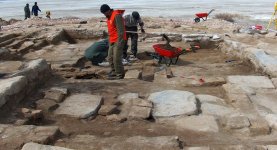
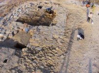
Kerderi is a group of abandoned settlements located on the dried seafloor of what was once the Aral Sea, in Kazakhstan. Kerderi is thought to have been inhabited around the 14th century, when water levels were low enough to expose dry land.It is not known when Kerderi was abandoned. However, some objects from Kerderi have been carbon-dated to as late as the start of the 16th century and historical evidence suggests that the Aral Sea began slowly refilling after 1570, when the Amu Darya river resumed its flow into the Aral.
- Kerderi was completely flooded; at 1960 water levels, the settlement was inundated under 19 metres (62 ft) of water.
- When the Soviets diverted the Amu Darya and Syr Darya after the 1960s, the Aral retreated once more, and Kerderi became accessible for the first time in modern history. The settlements were rediscovered in 2001.
- They have since served as important evidence of the Aral Sea's historic changes in depth.
- Kerderi
- Secrets of the Aral Sea
There are three distinct sites at Kerderi, which have been named Kerderi-1, Kerderi-2, and Aral Asar. The settlements are known for the ruins of two mausoleums. The inhabitants of Kerderi-1 had access to fresh water from the Syr Darya, which once meandered nearby. Archaeological evidence shows the inhabitants grew rice and wheat, and also raised livestock. Aral Asar drew the benefits of trade as a stop on the Silk Road.
The Caspian Sea
- I am not a professional overlayer, but it should give you a general idea of what happened sometime after 1640.
The Aral Sea
- We discovered America in 1492, but noone bothered to map the Aral Sea until 1848. Isn't it strange?
- Luckily this is not really the case. There are plenty of maps suggesting that the area was mapped plenty of times.
1593
Source
1610
Source
1635
Source
1655
Source
1686
Source
1698
Source
1706
Source
1719
Source
1720
Source
1730-37
Source
1739
Source
1741
Source
1780-88
Source
1783
Source
1786
Source
1793
Source
1801
Source
1844
Source
KD on Maps: Dating of some of the above maps is questionable, imho. In general, it appears that something major happened between 1655 and 1686. Over a half of the Caspian Sea just picked up and left.
- The first time we can spot any body of water at the approximate location of the future Aral Sea is between 1730 and 1737.
- We also have it named Lac Oxianes. Google translated Lacus Oxianes as Aral.
- It appears that at first we had no lake or sea there. Than we had a lake. That lake was getting bigger and bigger, and became a sea.
Dating
I keep on thinking that for some parts of the world, our texts and our maps are off by 100 years. There a few reasons for that, and this here is one of those. From the historical perspective, some things make more sense when this possible 100 year offset is taken into consideration.Is this how they were indoctrinating things and places?
- Step 1. Mention Peter the Great who visited Paris in 1717 and already knew about the Aral Sea.
- Step 2. Make a claim that due to this or that Caspian and Aral Seas were never one and the same.
- Step 3. Put the above info into text books, and start teaching the narrative.
As we can see, in 1762 the Aral Sea-Lake was reported to be 150 miles long and 70 miles wide. This is consistent with the maps from the same time period. Compare this to 1960s:
- The Aral Sea’s greatest extent from north to south was almost 270 miles, while from east to west it was just over 180 miles.
- Looks like the size of the Aral Sea was never something constant.
Receding Waters
I do believe that the Caspian Sea and the Aral Sea were one and the same prior to 1655-1686. But what's truly interesting is that our oval shaped Caspian Sea we see on the maps predating 1655, was not always that big. In my opinion, the oval shape was formed by the same cataclysmic event that triggered the Age of Discovery. The below Sabayil Castle can explain why I think so.Sabayil Castle
In 1235 Shirvanshah Fariburz III had a fortification built on one of the rocky islands of the Baku bay which was subsequently called the Sabael Castle, Shahri Saba, Shahri Nau, the city under water, the caravanserai, the Bail rocks, etc. Wrapped in legends, the castle is completely under water at present and is about 350 meters distant from the shore.- In 1306 as a result of a strong earthquake in the south of the Caspian and the rise of the sea level the fortress sank into the water.
- From the beginning of the XIV century and to the beginning of the XVIII century the building was flooded with the Caspian waters.
- In 1723 in connection with the abatement of the water level in the Caspian the top of the tower appeared from beneath the water.
- The upper part of the building is completely destroyed, only the lower part of the walls and the towers reaching in some places about 1,5-2 m high is surviving.
- Source
The archaeological investigations of the castle were carried out in 1939, 1940, 1946, 1962 and 1969. In the course of the excavations the foundations of 9 habitual premises were discovered, two of them had a hearth. About 700 stones with inscriptions, fragments of earthenware crockery of black and red baking, intact vessels, copper coins of Shirvanshah Kershasb (1203/4-24) and others were lifted from the bottom of the sea. Also were found the fragments of potter’s pipes of different diameters which seemed to be water-pipes. At present part of the stones lifted from the bottom of the sea are displayed in the museum of the Shirvanshahs’ Palace.
In the early 19th century, well-known Azerbaijani historian A.Bakikhanov wrote:
- The towers that can still be seen in the sea before the city of Baku, the walls, gravestones and descriptions written by historians about the former condition of this city show that what was urban 400 or 500 years ago is now submarine.
- Presumably, these places will surface again sometime in the future.
- Source
- There is a fortress in the sea near Baku,
- This new fortress went down in flood.
- Source
- Sabayil Castle - Wikipedia
- Sabayil Castle
- Mystery of the Sunken Castle Sabayil: Many Questions Still Plague Archeologists
- Submerged ruins of Bayil Fortress
- Bayil Tower
KD summary: As far as I understand, some time prior to 1400, there was a major catastrophic event of biblical proportions. I do not know if it was the Noah's Flood, but it was the flood that changed the world. Once the waters receded, the oval Caspian sea was formed. At this point we are talking about the late 14th or early 15th century. Then, something happened again, this time between 1655 and 1686, and the oval Caspian Sea lost over 50% of its waters.
- In approximately 1730, the Aral Sea started to form in the area previously occupied by the oval shaped Caspian Sea.
- Methinks, they need to be stripped of their degrees and statuses for their failure to notice that over the span of some 200 years, this world lost close to 70% of the Caspian See. The world did not even blink.


