Welcome to Tenochtitlan as it was in 1520

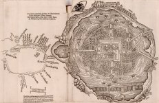
Between July 1519 and September 1526, Hernando Cortés (1485-1547), the soldier and adventurer who in 1519-21 conquered for Spain what is now central and southern Mexico, sent five extended letters to Emperor Charles V in which he described his exploits and placed himself and his actions in a favorable light. This book contains the first Latin edition of Cortes’s second letter. In it, Cortés gives an account of his first meeting with the Aztec emperor, Montezuma II. Dated October 30, 1520, the letter was translated from Spanish into Latin by Petrus Savorgnanus and printed in Nuremberg, Germany, in 1524. This printing also contains the first published plan of the Aztec city of Tenochtitlán (present-day Mexico City), which Cortés and his army attacked and destroyed in May 1521. Also included is an early map of the Caribbean Basin.
  • This printing contains the first published plan of the Aztec city of Tenochtitlán.
1520
Tenochtitlan_1520_1.jpg

Tenochtitlan_1520_1x.jpg Tenochtitlan_1520.jpg

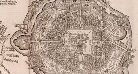
Am I the only one, or in 1520 Tenochtitlan looked like a European town, considering that it was only conquered in 1521? Who built all those European looking buildings?

Moctezuma II
How native does he look?
Moctezuma II_2-1.jpg

A very nice double-headed bird there... HRE?


Temix Titan = Tenochtitlan
temix titan_1.jpg

Source titled, "The Splendid Narrative of Ferdinand Cortes About the New Spain of the Sea and Ocean Transmitted to the Most Sacred and Invincible, Always August Charles Emperor of the Romans, King of the Spaniards in the Year of the Lord 1520: In Which is Contained Many Things Worthy of Knowledge and Admiration About the Excellent Cities of Their Provinces…Above All About the Famous City Temixtitan and Its Diverse Wonders, Which Will Wondrously Please the Reader"
KD: Makes me wonder why Cortes himself would call the city Temix Titan? We all know the traditional meaning of the word Titan.
  • In Greek mythology, the Titans were members of the second generation of divine beings, descending from the primordial deities and preceding the Olympians. They ruled during the legendary Golden Age, and also comprised the first pantheon of Greek deities.
The city itself appears to have multiple traits of the so-called European architecture. Why?
 
I don't know, Korben, it seems too fast to me the way the old Tenochtitlan disappeared and built a European-style one or something like that.
I'm with you on that. I also want t know what body of water we have on this image. And if this is indeed Lake Texcoco, why we have ships like this sailing in it.

Additionally, how do you get rid of a lake of this magnitude with the technology available at the time?
  • Unless some calamity assisted with draining.
  • Lake Parime is another example of a vanished lake.
 
There are all manner of roof styles in that map supposedly showing Lake Texcoco. It has the feel of a 'fantasy island' type scenario to it. Wonder what or who it was produced for.
 
Wondering if this Vinius’s table specifies the location of the Swedish Mexico City.
 
Just today that I was looking at images, I saw one about the city of Quinsay and an old theory that I had read a long time ago came to my mind and I will share it because it is very interesting ...

quinsay_567.jpg

Johannes Schoner (1477-1547) who assured in 1523 that Tenochtitlán, the city conquered by Hernán Cortés two years earlier, was the Chinese metropolis of Quinsay, the “City of Heaven”. This statement was published in writing and on various globes and planispheres produced by him between 1523 and 1533.

Johannes Schóner had access to several testimonies, among them the second Letter of relationship of Hernán Cortés and also the Book of the wonders of the world, the famous Millione, by the Venetian Marco Polo. And of course Schóner was aware of what had been written about Columbus's travels and of those who later marched to those lands located to the west.

HB: The author of this article that I will leave you, tries to give his explanation of how this statement had to be a confusion ....

-In matters of geography, until then nobody had a global vision of the planet.
-Regarding what would be called the New World, especially the Spanish, Portuguese, Italians and English, little by little and groping many times with the participation of the indigenous people, they would get to know the profile of the great continent. It is known that the one who triggered the process of the meeting, Christopher Columbus, persisted in the persuasion of having reached the extremes of Asia.
-The world maps, planispheres and terrestrial spheres that were produced later during the first half of the 16th century and subsequent years, reflect the uncertainties. The one who was the pilot of the Santa María, Juan de la Cosa, drew a large map in 1500 in which, beyond the Antillean islands, a landmass appears that goes from the extreme north of the world to the ends of the south. What was there raised great questions.
It is exciting to approach the maps of cartographers such as Alberto Cantino (1502), Nicolás Caverio (1502), Francisco Roselli (1506), Giovani Matheo Contarini (1506) and check how the uncertainties that sometimes translate into daring hypotheses persist. A canon of the city of San Dié in Lorraine, Martin Waldseemü-lIer, published in 1507 a pamphlet entitled Introduction to Cosmography, precisely to the work of Claudio Ptolemy. In this Introduction, inspired by the writings of Americo Vespucio about a Mundus Novus, and on the world map of Nicolás Caverio, he presented a delineation of the lands that were becoming known as a "quarter of the world." The southern one gave it the name of America there to honor the memory of Vespucci.
-What was elaborated by Waldseemüller was far from putting an end to the uncertainties and discrepancies.
-In fact, the unknown, as regards a possible terrestrial link between Asia and America in the extreme northwest of it.
HB: And so, you mention an endless number of cartographers.

"These new lands (those of the western hemisphere) belong to the continent of Upper India, which is a part of Asia ..." (Schoner c.1523, 10.)

In this interpretation of Magellan's trip, Schoner followed the opinion of Maximiliano Transilvano, a secretary of Carlos V, expressed in a letter written in Valladolid in the late 1522. Addressing Transilvano to the cardinal of Salzburg, he reported in it what he knew about the recent trip of Magellan, hinting that the union of the so-called New World with Asia could be concluded from him.

1671 Ogilby, John, 1600-1676.jpg

1671 Ogilby, John, 1600-1676​

Schoner identifies Mexico-Tenochtitlan with Quinsay, the "City of Heaven." Let's see what he wrote about it.

Mexico-Temistitan in Upper India or, rather, in Cathay, China.

Without hesitation on this point, Schoner expresses this in his Opusculum Geographicum: "Following a long circuit, towards the west, starting from Spain, there is a land called Mexico and Themis-titan in Upper India, which the ancients called Quinsay, that is to say the City of Heaven ". (Schoner, c. 1523, 12.)

To find out the location that was attributed to Quinsay we can go to the world map of Henricus Martellus, the aborado in Nuremberg around 1490. In it, the image of the world of Ptolemy remains, although already highly enriched.

Quinsay appears in the eastern end of Asia, as one of the two largest cities on Earth and precisely built on a large lagoon. As much in the terrestrial globe of 1523, as in another one of his of 1533, Schoner delineates such a union of America with Asia. Schoner, a native of Nuremberg, where he worked, knew that world map. In addition, as a certain thing it can be affirmed that he had read at least the part of Marco Polo's book in which he speaks of Quinsay, explaining that it was the "City of Heaven". In describing it, he points out that it also went by the name Hang-Tcheou, which lasts to the present. Marco Polo refers that Hang-Tcheou, by another name Quinsay, was the capital of Manzio southern China. In describing its splendor, among other things, he comments that:

It is so big that it has a hundred miles per circuit and has twelve thousand stone bridges ... Because you have to know that this city is all built on the water that surrounds it everywhere. It is convenient, therefore, that there are so many bridges.

There are splendid palaces and rich houses belonging to the nobles of the city. Many idols are also kept, and numerous monasteries ...

There are more than three thousand bathrooms in it ... Merchants arrive there loaded with various products ... Its inhabitants are excellent men of war ... When a child is born to them They put in writing the day and time of their birth and under what sign it occurred. When [later] someone wants to travel, he consults an astrologer to see if he should undertake the trip or not ...

People burn the bodies of those who die ... The palace of the supreme ruler of Manzi is the largest in the world ... Inside there are very beautiful gardens ... The city receives immense tributes ..., forty times five thousand six hundred gold pesos ... (Marco Polo 1988, 82-90.)
Regarding what Hernán Cortés expressed about Mexico-Tenochtitlan in his second Letter of Relationship, dated October 30, 1520.

This letter was published very soon in Spain. It appeared in Seville. in the printing house of Jacobo Cromberger, in November 1522.

It being possible that Schüner read in said Spanish edition the description of
The metropolis that Cortés conquered, it is also possible to think that he had access to the printing of it in German, which saw the light in March 1524 and precisely in Nuremberg, where Schoner worked. This last one moves to affirm that the Treaty where he identified the Mexican metropolis with the Chinese one, was written and printed not in 1523, but about a couple of years later.

Let us now look at Cortés de México-Tenochtitlan's description without losing sight of the transcription that I have made of what Marco Polo expressed about Quinsay.

HB:
  • As you will see, the work of Johannes Schoner compares what was said by Marco Polo de Quinsay and what was said by Cortes de Temix-Titan, which by the way sound very similar.
  • It also touches on the theme of America united to the Asian continent.
  • Not exactly Cathay was referring to the Chinese I think, being this on occasions above China in ancient maps, perhaps it was the Cathay (Tartaros) that dominated China in the form of the Qing dynasty?
  • I know that you have already touched on many of these topics but I did not see something like what Johannes Schoner proposed and I knew it was a good opportunity to know what you think of all this, greetings!

Search in: México Tenochtitlan: metrópoli de la China
 
There appear to be a lot of similarities between the too. This is very interesting and intriguing. Thank you.
 
I have never seen Mexico City being called Villa Ricca before.
  • I do see Timistitam, or whatever that name is, but I do not think it pertains to the lake.
    • It appears to be related to some place farther west.
  • 1568 Map
villa-ricca.jpg

It’s all in Spanish here, may be you can find something useful.
 
I have never seen Mexico City being called Villa Ricca before.
  • I do see Timistitam, or whatever that name is, but I do not think it pertains to the lake.
    • It appears to be related to some place farther west.
  • 1568 Map

It’s all in Spanish here, may be you can find something useful.
Very interesting that the map also shows America united with Asia. California is still united with what will become America later.


I say it, because you already know about the legends that arose in the middle of the conquest on the Island of California.

Esplandian.jpg
sergas de explandian..jpg


The Sergas de Esplandián.
While the pagan troops tighten the siege on Constantinople, Montalvo makes let the reader participate in an extremely spectacular event.
The Indies, the earthly paradise, black women who live like the Amazons, with an inexplicable prominence at first glance.
  • "Know that at the right hand hand of the Indies one egg Island called California, much arrival to the part of the earthly paradise, which was populated by black women without any male among them having, that almost like the Amazons was their way of life "
  • CALIFORNIA, THE AMAZONS AND THE TROYAN TRADITION

The work Las sergas de Esplandián recounts in 184 chapters the adventures of this knight, the first-born son of Amadís de Gaula and the princess Oriana of Great Britain. Carried in a flying boat - the whip of the great Serpent - to the rock of the enchanting Maiden, he seizes there an enchanted sword, then reaches the Defended Mountain and in the castle of the Peña Tajada he kills three giants and frees his maternal grandfather King Lisuarte. Kill the giant Bramato and free Gandalín and Lasindo, and have other adventures. He also falls in love with the Infanta Leonorina, daughter of the Emperor of Constantinople, with whom he maintains a chaste idyll, and fights with his own father, Amadís, who challenges him to prove his courage, without Esplandián, who is the winner, knowing his identity. . However, most of the book is devoted to recounting the hero's incessant battles with King Armato of Persia and the Muslims, who form an alliance to seize Constantinople and subject it to a terrible siege, which ends with the victory of the Christians. At the end of the play, Esplandián marries Leonorina, and the Emperor of Constantinople abdicates the crown in her favor.
One of the fictional place names included in the work, that of the Island of California, lordship of Calafia, Queen of the Amazons (who falls in love with Esplandián but ends up married to her cousin Talanque, Galaor and Julianda's extramarital son) achieved notoriety. when the Spanish conquerors imposed it on what is now a vast region of Mexico and the United States.
While in the Amadís de Gaula the reported confrontations took place exclusively between Christian and European knights, Las sergas de Esplandián introduced for the first time in the Amadisian cycle the theme of a great warlike confrontation between Christians and pagans (including Muslims) , that was repeated incessantly in almost all the other books of the series, as much in the Spanish amadises as in the Italian, German and French, as well as in many other books of Spanish and Portuguese chivalry.
  • Las sergas de Esplandián
  • Author Garci Rodríguez de Montalvo
  • Published: July 1510
  • HB: That 1510 is 12 years before the fall of Tenochtitlan, which makes it interesting. Apparently, Queen Calafia gave the name to California.
Reina+Calafia+Loreto.jpg
californiathemagicislandcover011.jpg
5.jpg

His queen Calafia and his country California.

Su reina Calafia y su país California.jpeg

There are images of Amazons from Monopotama, from the Amazon, from Isla Mujeres in Yucatan. There are many legends about them as Fomenko said, since according to the Amazons of "Greek" mythology they were the women of the Scythians, Tartaros, then Cossacos. Upon arriving in America it was normal to find stories of them here.

I think also, in this last representation of a tattooed Amazon that looks Celtic, the resemblance is interesting.

9bc03ae301bc837658741302b5aa41a0.jpg
45db18b7de2051f1605d517ac72665e7.jpg

Similar to these Algonquian avatars and what about the Chachapoyas tribe and its possibility of Celtic origin.The chachapoyas would have been conquered by the Incas in the time of the ruler Túpac Inca Yupanqui. The chronicler Cieza de León collects some picturesque notes about the Chachapoyas.
"They are the whitest and most graceful of all those I have seen in the Indies that I have walked, and their women were so beautiful that because they were, and because of their kindness, many of them deserved to be from the Incas and to be taken to the temples of the sun. [...] they and their husbands are dressed in woolen clothes and they used to wear llautos on their heads, which are a sign that they bring to be known everywhere "

Avatar described by Smith
braveworld_dec08_2.jpg

HB: This play on words catches my attention, Nueva Galicia or Xalisco, Galicia in Spain, Galicians, Basques, Wales, Gaelic, Irish, Celtic origin, come from the Scythians.
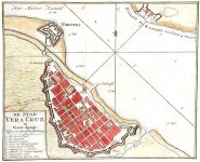
On the map that you send me, perhaps it refers to the Villa Rica de Veracuz. Look, on this map he points out the Villa Rica de Veracruz.

Veracruz, therefore, is where Hernan Cortez is supposed to have been received by an Embassy sent by Moctezuma to receive them, since they thought it was the god Quetzalcoatl who was returning.
It was also right there where the Aztecs-Mexica realized that they could not be the gods, because they did not have the minimum respect for their laws of behavior.
In that area lived the Totonacas, who were supposedly among the first to join the Cortes against Moctezuma and that is why the war began right here, then they joined the Cortes: the Otomies, Tlaxcaltecas, finally some rebellious Aztecs from the triple alliance.
According to it is said, the Tlaxcalans were already about to exterminate the Spaniards in their territory, luckily theirs suddenly decided to join them. This in the "Official" story.
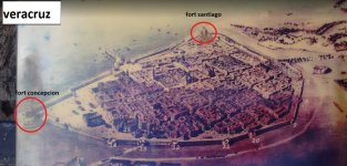
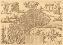
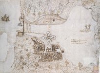
Personally, I am surprised at how quickly they built stellar fortresses in full colonialism, with their technology, with their donkeys and horses, in addition to all the buildings within these fortresses.
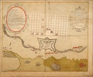
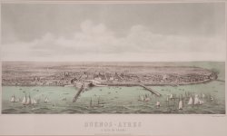
I was able to realize Argentina (Buenos Aires), Cuba (Havana), Uruguay, Mexico (Veracruz), Peru (LIMA).

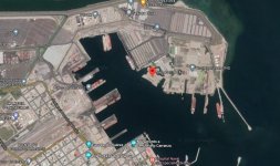
Mexico (Veracruz)
2.jpg VERACRUZ ULUA.jpg 7.jpg

Peru (LIMA)
PERU, LIMA.jpg

Cuba (Havana)
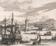
HABANA CUBA.jpg havana CUBA.jpg LA HABANA CUBA OGILBY 1671.jpg MAPA DE LA HABANA CUBA.jpg

Uruguay (Monte Video)
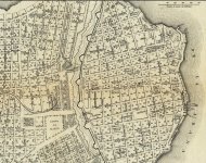
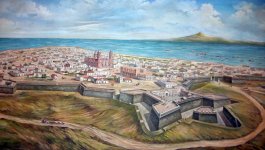
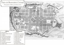
MONTE VIDEO, URUGUAY.jpg MONTE VIDEO, URUGUAY2.jpg

Argentina (Buenos Aires)
plano-de-buenos-aires-1713.jpg Museo_del_Bicentenario_-_'Buenos_Aires_a_vista_de_pájaro'.jpg

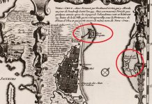
On the map of Chatelain 1719, the fortress of Veracruz appears and next to it a Giant supporting a Native American on top, reminded me of the Circassians with their Fluffy hair (Afro).

4.jpg

I was reviewing the map of 1521 and it is obvious that it was made by someone who spoke Spanish, because I was able to understand certain parts of the map well, others very illegible.
In the upper left corner is the castle of Chapultepec, to the central right is the market, I see only the names of saints: Santa Catalina, San Jose, Santo Domingo and etc.
There was a church "Iglesia Mayor", I thought I had seen it before and I think I'm sure it looks a lot like the basilica of Guadalupe, where the Virgin of Guadalupe is supposed to have appeared to the Indian "Juan Diego". As you know, in Mexico they are very Guadalupanos, it strikes me that by this 1521 the map already shows many churches, that building of the bird that looks like a mosque, that I could not read the name, which should be impossible because it would suppose that the basilica would be in standing in the fall of Tenochtitlan.

1521.jpg

1521-2.jpg
basilica de guadalupe.jpg
antigua basilica de guadalupe2.jpeg
antigua basilica de guadalupe4.jpg

I found this video about the passage of time in Tenochtitla, they simply say that the lake dried up.
  • 0:03 -1330 Tenochtitlan, the primitive islands in the lake environment, the islet of Tenochtitlan (still uninhabited) and towns surrounding the lake. Atzacualco, Zacatengo, Licoman, Alepellac, Tenayuca, Pantlaco, Azcapotzalco, Tacuba, Tacubaya, Mixcoac, Xoco, Coyoacan, Culhuacan, Mexicaltzingo, Ixtapalapa.
  • 0:26 -1390 Tenochtitlan, Tlatelolco, neighboring towns and construction of the roads to Tacuba. Azcapotzalco and Tenayuca.
  • 0:40 -1420 Tenochtitlan, Tlatelolco, neighboring towns and construction of the road to Tacuba, (from Tenochtitlan to Tacuba).
  • 1:00 -Construction of the aqueduct from Chapultepec to Tenochtitlan.
  • 1:29 -1470 Construction of the roads to Coyoacan, Iztapalapa and Xochimilco.
    • -1490 Territorial unification.
  • 2:10 -1510 Construction of the Albarrada de Nezahualcoyotl.
    • -1519 the city had 200,000 inhabitants, the lake began to dry up and the landscape changed dramatically.
  • 2:39 1750: Mexico City (Capital of New Spain) has 100,000 inhabitants, in addition to preserving the old roads.
    • -1850 200,000 inhabitants.
    • -1950 3 000 000 million inhabitants.
    • -2010 8 000 000 million inhabitants.
From 1521 to 1700 the water disappears.

 
Moctezuma II
How native does he look?
Moctezuma II_2-1.jpg
A very nice double-headed bird there... HRE?
The descendants of Moctezuma II still belong to the Spanish nobility today.
In 1865 they were awarded the ducal title.
  • "With the revaluation of the aristocratic title, the Moctezuma house was to be offered a kind of compensation for the fact that no descendant of Moctezuma II, the old ruling dynasty, had ascended the throne of the Mexican Empire in the previous year."
  • Source German Wiki
Moctezuma_de_Tultengo.jpg
 
@HELLBOY, What do you think about this 1808 map here?
  • Is that how it was supposed to be (per the PTB) back then?
I say that the map fits perfectly with what we can see today via satellite.

MAPA DEL LAGO DE TEXCOCO.jpg

We see downtown Mexico City, I mark it with lines.
There near the Castle of Chapultepec, further down the Chinampas of Xochimilco and we arrive at the Chalco lagoon.

LAGO DE TEXCOCO.jpg

I took a snapshot of the same area today, mark the same areas. Mexico City, Castillo de Chapultepec, xochimilco, Laguna de Chalco.
Add the Texcoco lagoon this time.

1671 Ogilby, John, 1600-1676.jpg

I was about to tell you that I still believe that this ancient "Temix-Titan" from Ogilby's 1671 engraving is in a very small lake.

laguna de texcoco.jpg

When I was zooming in to recognize the Texcoco area, it turns out that I come across certain anomalies that don't seem like the remains of some building or buildings, perhaps a city.
Isn't this the Temix-Titan from Ogilby's engraving?

Even in the lagoon above, that of San Cristobal seems to have certain anomalies and the "classic" one, a military base.

LAGUNA DE SAN CRISTOBAL.jpg

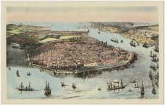
From the book Mexico Litog. de Decaen Search Results: All Fields similar to 'Veracruz' - David Rumsey Historical Map Collection , with drawings by C. Castro, J. Campillo, L. Auda and G. Rodriguez, under the direction of Decaen Editor. Decaen Lithographic Establishment, Publisher, Portal of the Old Colosseum. Mexico, 1855 and 1856.
David Rumsay made a very high resolution copy of this book and you may be interested in exploring it.
It is a great treasure because there are not many engravings on Mexico from ancient times, this according to the date given is 40 years after the independence of Mexico.
In no image do you find a single car, the first dealership was opened in Mexico in 1901 and by 1903 the sale of Oldsmobile cars in Mexico City was announced in the press.
So we see a strong contrast between people and beautiful construction, you can see the varied architecture, a shot of the city in a balloon, which, although it does not leave a trace of what Ogilby presented in 1671, does let us see the architecture in contrast with what they had in those times.
The images allowed me to check what the Urbano Monte map said about the fact that in Mexico there were trees so gigantic that boats could be made from one piece.

arbol de chapultepec.jpg
arboles gigantes de urbano monte xalisco 1587.jpg

The city of Veracruz also appears and is quite similar to the stellar cities.
 
Have you ever checked the coat of arms that belonged to Hernan Cortes?

Complete coat of arms of Hernan Cortes. To the coat of arms granted by King Carlos I of Spain in 1525 he added a shield of the Cortés de Monroy family (In gold, four clubs of gules. Border of azure with eight silver crosses of St. John of Jerusalem. Blazon of the Iberian consanguinity) charged with his motto Judicium domini aprehendit eos et fortitudo ejus corroboravit brachium meum (The heraldry of Hernán Cortés) and a winged lion (Griffin) on the helmet that Cortés added to the shield.
He continued to represent Tenochtitlan in a very European way.

Some interesting pictures

The_entrance_of_Hernan_Cortés_into_the_city_of_Tabasco.jpg

The entrance of Cortés in Tabasco. Painting from the second half of the 17th century. Collection of Jay I. Kislak in the Library of Congress of the United States of America.
The_sad_night.jpg

The sad night in which Hernán Cortés, his army of Spanish conquistadors and their native allies were expelled from the Aztec capital, Tenochtitlán.
The Moctezuma de Ronda family was the main branch and included the only direct male heir of the last Aztec emperor, Moctezuma II (1502-1520) Charles V granted the family its own coat of arms in October 1539 We can see this historical coat of arms carved on the front of the palace: thirty crowns representing the thirty states that formed the Mexican empire, the eagle, the ocelot, the griffons and the imperial crown.

escudo-de-armas-moctezuma-50754055.jpg
 
i just wonder why tenochtitlan, 1520 painted by cortes, has the same shape that the planet, earth. as showed by convex earth theory.

yes, in the 1520 map, the lake in general a circle, with an extra bump like psrt of a circle inserted, which in the map it is in the west of the lake.
arra which is also separated from the big lake in this 1520 map.is artificially separated by a manmade wall.

in the convex earth theory, bump is separated my a wall of ice.

seems that the people of temiix titan ,mexico, gave shape to the area where they live acording to the shape of the planet.

that is not uncommon in the area, at the north of mexico city miles away the toltecs built tenochtitlan, with the shape on the mountains of the mexiico valley. and miles at the south, of mexico city, a previous civilization - megabuilders- literally transformed the shape of the mountains into pyramids,sphinxs, larger than the giza pyramids, snd sphinxs ( and literally cut other mountains with technology not know now)
and in the south of mexico city, there were carved, dig, build channels in the lake for communication.(xochimilco) in the same way to the ones 9000kms of river channels in the east of usa, or on other parts of the world made by previous civilizations.

the pyramids in giza, mayas,etc around the world,re done with ratio,numbers and vision of the world.(like above, like below)

and in he lake of tenochtitlan, 1520 they gave the shape of the earth which is same to the results of measuring the earth, according to the convex earth theory, shape.
 
Last edited:
I visited Mexico City last year The history museum and Chapultepec castle . I have video with the explanations of the guide about the history of the place. Mexico City is sinking there are proofs of that in the streets that have a deep slope, Chapultepec castle is on a hill mound could be a pyramid in the center of the city. I visited Cholula and I have video and also Teotihuacan which is the most amazing place.
I stayed in the city center which theoretically was part of the old city.
The cathedrals have doors for people extremely tall and of normal size. The old city was apparently standing 500 years ago. The plaza is still there. The immensity of the cathedral is hard to comprehend. In the center of the city the Spaniards actually demolished a very large pyramid according to the guides. In the subway there are archeological ruins of large columns destroyed.
National Anthropology Museum Mexico City


Metropolitan Cathedral Mexico City


Another Cathedral in Mexico City


Teotihuacan Mexico


Mexico city at night Old buildings

 
Similar articles
Article starter Title Section Replies Date
KorbenDallas Welcome to the Vatican Library Secret Archives... you are not! Vatican 4

Similar articles

Back
Top