Antwerp: authorities rebury our true history?

Our official archaeologists experience an orgasmic ecstasy when they find a stone arrowhead, an axe or discover an ancient fireplace. And there go the headlines:
  • World's Oldest Bread Found In Ancient Fireplace After 14,400 Years.
  • Earliest Bone Arrowhead, 61,700 Years Old, Found in South Africa
  • World's oldest known ground-edge stone axe fragments found in Western Australia
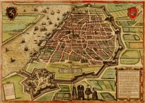
Yet, anything and everything capable of exposing the unpleasant truth gets destroyed, hidden, or dismissed as something insignificant. And we have plenty of proof of such actions when proper attention is being paid. I ran into a Reuters article titled, "Monumental 16th century city walls unearthed by Antwerp tram works". I knew that this Belgian city used to have a star shaped design, so wanted to see the walls. Good luck trying to find this star shaped design on the today's maps. Interesting that Antwerp is old to the point where the approximate date of its founding should probably be listed as "we do not really know."

antwerp_old_map_2.jpg

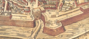
antwerp_gate.jpg antwerp_old_map.jpg
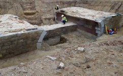
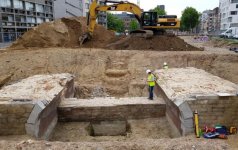
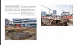
Now, this "excavation" took place in 2017. We have a few pictures and several articles pertaining to the find. We also have this outstanding double paragraph, kindly provided by Reuters.
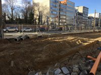
Parts of the bridge and city wall will be integrated into the design of the tram way, visible to passengers and pedestrians as part of a new plaza, the Operaplein. But much of the site will be buried in a way designed to keep it intact before a new road is built above.

“In the next decades, we will not see this again,” said Martens. “This is also the reason why we find it so important to document it so well.”

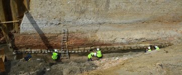
Here are a few pictures we have.

Archaeology.com states, "Parts of the monumental wall will be integrated into the design for the new tramway and plaza that will be built on the site. The rest will be recovered and preserved before a new road is built."


KD Summary: This is mind boggling. 30 foot walls are covered by dirt to the point where everybody out there is surprised to find them. Yet, instead of continuing to dig looking for whatever the hell happened, "the site will be buried in a way designed to keep it intact". Authorities will integrate a part of the wall into some existing construction project, and the rest of the wall will be reburied, and have a road built over it. Case closed.

Fun stuff ladies, and gentlemen. Nobody wants to dig deep. Finding the entire buried old city, controversial artifacts, as well as thousands of skeletons of the buried people does not fit within their dogmatic history. They want stone arrows, and decomposed wood structures.

Food for thought
According to folklore, notably celebrated by a statue in front of the town hall, the city Antwerp got its name from a legend about a giant called Antigoon who lived near the Scheldt river.

AtlANTis - ANTwerp - GiANT -ANTigoon

ANTique

Antigoon
The Founder of Antwerp
antwerp-founder-1.jpeg

Antigoon

Mexico - Egypt
mexico-egypt.jpeg

They were Ἄνται - Antae for us. But we know nothing about the real Ἄνται civilization. What we have, appears to be anything but the truth. I think they were the real builders of the ancient architecture.
 
Wow this is too much to stomach! Especially when you see the size of the walls next to the humans. It’s mindbogglingly destructive and evil to bury these and build roads over them. Shame on them.
 
Last edited:
If you are still interested in my opinion; this is a long read in Dutch about the Giant of Antwerpen which is a very known story.
Somewhere in the story they replaced Reus (dutch for Giant) wit Rus (Russian) and that made me think.

I totally don't understand why they bury this wall.
Normally they brush off every Roman coin or piece of an ancient pottery and display it and Belgium is burying it's heritage.
Why?
My parents lived in Belgium for a short time and honestly, this is not surprising.
They replace everything with uglyness; old farms are replaced with ugly new "modern" houses.
They take away everything green (leaves of trees are dirt and they vacuuming their yard ) and replace it with stone gardens and then they are surprised that half of Belgium is flooded.
walls next to the humans
Look at that piece of grey stone at the corner; it is perfectly carved (?) in a round form.
 
maybe someone will try?
Well they used the same photo's as the above website only some additional text.

Like that they will integrate some of the wall into an underground parking, that the wall had been renovated many times with different bricks or re-used , that they used mostly lime mortar, that it was gradually demolished around the 19th century and used as a foundation to build streets on top.

Here is some info about the Spanish wall
The Staats-Spaanse Lines are a system of military defense lines, created during the Eighty Years' War (1568-1648) and the War of the Spanish Succession (1701–1714) in the north of the county of Flanders.

Here some info about the mentioned achitect
Donato de Boni di Pellizuoli († 1556) was an Italian architect and fortification engineer working for and during the time of Emperor Charles V.


Here some info about the style of fortification
The old Dutch fortification system is a way of designing and building fortifications adapted to the Dutch raw materials and landscapes.

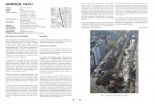
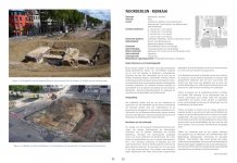
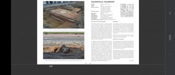
Here are some additional screenshots from that magazine that are not published on that website:
 
When further researching this, I found a news posting on the mobile website The Spanish ramparts. It says, this website was created in 2014 (Link), three years before the "excavation" in 2017.

From what I understand when reading the text on this website, what we are supposed to see being "excavated" in the initial posting are below ground remnants of the spanish ramparts, giving us a blueprint of their former location. We're being told the whole above ground "spanish ramparts" were demolished in 1860.
"The early sixteenth century saw the development of several new war techniques and arms. As a result, the late-medieval fortification around Antwerp was no longer deemed sufficient. Emperor Charles V ordered the Italian engineer Donato di Boni to build a wall around the city with bastions. The new Spanish ramparts were built in the period from 1542 until 1553 and comprised five monumental gates, eight sections of wall and nine bastions: pentagonal bulwarks which jutted out of the wall.

All the walls were built in brick and clad with white stone from Glabbeek. The walls were ten metres high and had a parapet that was maximum two metres high. At the time, the Spanish ramparts were considered one of the most modern defences and even today, they have special cultural-historical value. At the end of the sixteenth century the citadel of Antwerp was incorporated in the Spanish ramparts on the south side. The Duke of Alva built the citadel in 1567.

In the nineteenth century the Spanish ramparts were no longer useful. When the Brialmont city wall was built in 1850, the old ramparts prevented future development. As a result, the decision was made to demolish them in 1860. Nothing was preserved above ground level but the complete blueprint was preserved below ground. When the Leien were rebuilt, the archaeologists were able to study the remnants of these imposing ramparts for the first time.", Source: Google Translate from Dutch, URL Detail Spanish Ramparts
The following image embedded into this website is captioned with "The demolition of the ramparts in 1864" (the rightmost entry in the image gallery, direct link), while no artist information is given. This looks like a painting or part of a painting, however I couldn't find any further information on this image using reverse image search, except those leading back to itself.

Meer weten_SpOmw_beeld 7.jpg

Comparing this with the other official document quoted above I find further hints on the dimension of the whole construction.
"The Spanish ramparts were built between 1542 and 1553 by order of Emperor Charles. The work starts ten days after the siege of the city by Gelderland troops led by Maarten van Rossum. Both the city residents and the many foreign businessmen no longer felt protected by the outdated medieval city wall and demanded measures. Antwerp was now involved in the war strategy that Charles V introduced in his empire with the bastioned system. He commissioned the plan that the Italian engineer Donato di Boni had designed for the city in 1540. This design consisted of an almost five km long wall with four monumental city gates with access bridges, nine bastions, eight fronts (straight sections of the city wall), a wet moat and a masonry outer moat border. The gates in northern Italian Renaissance style were majestic. Fluted Doric columns, lions' heads, friezes and pediments appeared in the finish of the facade. The bastions were built according to the old Italian system, with long faces (fronts), short withdrawn flanks with low gun platforms accessible via posterns (masonry passages) and oreillons (ear or round transition) between face and flank. The bastion corners were given a pyramidal finish at the height of the moat and just above the foundation, decorated with a sphere at the top. Natural stone was used for the outer cladding or the facing.
Another novelty was the large earth wall behind the city wall and the bastions. This was accessible from the inside via earthen slopes and had a width of 34 meters. Only the canal side of the rampart was provided with a brick massif with white natural stone facing.
The decision to build a new bastioned rampart for the city of Antwerp led to an exceptional architectural achievement with social implications for the inhabitants. The entire medieval city wall was demolished for this purpose, as were all the buildings at the foot of the new ramparts.
The edict of Mary of Hungary of August 16, 1542 made a zone 'non aedificandi' (building-free zone) of 500 feet on the outside of the ramparts4. The following provisions applied here:
• all houses, buildings and trees must be demolished within 500 feet of the fortresses,
• in the city no new building may be erected within the zone of 100 feet from the rampart,
• bricklayers and carpenters are obliged to come and work (for a reasonable salary),
• no one is allowed to work on another building without permission,
• You may remove as much soil as necessary from places and courts close to the fortresses, with as little damage as possible to the owners.
Bastion Huidevetterstoren was built between 1551 and 1552 as the last stronghold of the ramparts. It defended the city between Keizerspoort and Kipdorppoort. The name referred to the nearby Huidevetterstoren from the fourteenth century, one of the few medieval towers that has been preserved in the new fortification.", Source: Google Translate from Dutch, De Spaanse Omwalling Bastion Huidevetterstoren, Rapporten van het Stedelijk informatiecentrum archeologie & monumentenzorg (SIAM), 17, page 4, kindly linked in AlgulSiento's posting above
The architect Donato de Boni di Pellizuoli, who Jinxy identified above, was educated by Michele Sanmicheli (Wikipedia).
Michele Sanmicheli (also spelled Sanmmicheli, Sanmichele or Sammichele) (1484–1559), was a Venetian architect and urban planner of Mannerist-style, among the greatest of his era. A tireless worker, he was in charge of designing buildings and religious buildings of great value. (Wikipedia)
The contemporaries of di Pellizuoli didn't seem to have a very good opinion about him:
After negative inspection reports from Giovanni Maria Olgiati and Sebastiaan van Noyen , De Boni received no new orders from 1553 onwards. (Wikipedia)
"Negative inspections" leading to absence of orders is not exactly what I expected to read about this modern day "Hemiunu" planning and building such a massive structure as these "spanish rampants".

Looking at the works attributed to Sanmicheli, Olgiati and van Noyen, I can't see any connection between these styles and the look of the "excavated" "spanish rampants".

Other buildings, for example the "Bourse of Antwerp" (actually the first version of it, gothic style, 1531, burnt down in 1583, does look much more like the styles of these guys. To compare, you can find images of the different Handelsbeurs versions in the dutch Wikipedia article).

The catacombs of Antwerp below instead look very similar to the "excavated" "spanish rampants", red brick and white cladding (Image taken from Tourist Website).

150519ruien0511.jpg

I hope I am not overstretching it with referencing the following paintings by Pieter Bruegel the Elder (both images from Wikipedia).

Pieter_Bruegel_the_Elder_-_The_Tower_of_Babel_(Vienna)_-_Google_Art_Project_-_edited.jpg
300px-Pieter_Bruegel_the_Elder_-_The_Tower_of_Babel_(Rotterdam)_-_Google_Art_Project_-_edited.jpg

These paintings are thought to be made in 1563. The artist was member of the Guild of Saint Luke in Antwerp. They are thought to be showing the "Tower of Babel", red bricks on the inside, white cladding on the outside.

The following points I can't understand:
  • Why would one of the greatest established artists of this time, who could well have witnessed the construction of the "spanish rampants" (if official story was true), use the building style of a then contemporary military fortification as the inspiration for his paintings of a biblical myth?
  • How can a structure like this 5 km long x 10 m high (or is it 10 m "excavated" foundations and 10 m walls + 2 m parapet above ground = 22 m high half buried construction) "spanish rampants" with all these gates etc. be built in eleven years?
I am a complete amateur with no knowledge about history, architecture or art. I think what might have happened is that people found these existing structures, which we're told today are these "spanish rampants" and used them to settle. At one point in their economic growth these older structures get used, and at one point in their history, as if adorning themselves with borrowed plumes, the older structures become attributed as one of your own achievements.

Also the height of the structure keeps puzzling me. The exavations go quite deep visually. If above ground structures were present, it would be more than the 10 m height which are reported in the sources.

I found another peculiar text in Wikipedia, about one of the main gates of the "spanish rampants", which adds to the confusion:
"In the 19th century (1864-1865) the Kipdorppoort and the ramparts were demolished to make way for the Antwerp boulevard . Only the cobblestones and the top one and a half meters of the natural stone facing were dismantled. The Kipdorp Gate disappeared completely. The city moat was filled in with the demolition material and the lower walls disappeared under the slates." (Google Translate from dutch, Wikipedia page on the "Kipdorp Bridge")
To me it boils down to this single question: why are the "spanish rampants" so deep underground nowadays they have to be "excavated", when the official sources are true? It's not just the question who really built it and when, but also the fact they are still there and how they are looking now, is asking additional questions on top of that for what really happened.
 
Last edited:
they have to be "excavated"
They have a folder with additional info, can be downloaded here.

Screenshot:

Screenshot_20210819-140058.jpg

As you can see they even have photo's of the bridges and forts and it was all under water with canals. So why did they not know the walls and bridges were buried if they seem to have all kind of information up until the 16th century.


It's not just the question who really built it
Well so they built a huge wall on land and a few years later some Italian / Spanish (strange story) duke of Parma guy just takes it over via the sea.
A strange description of the happening (translated)

Parma devised a genius plan to block the Scheldt by a ship bridge. Halfway through the Scheldt estuary and the city, he had two fortresses built on both banks of the river, Sint-Philips and Sint-Marie. His engineers built two bridgeheads in the river from those two forts. They piled (heypoles) heavy logs in the river to where it became too deep and set up six guns on each side of those bridgeheads. Between them they built a ship bridge that spanned the remaining 300 meters. The bridge consisted of a large number of barges, each equipped with two small cannons. On February 25, the bridge was closed. Three days later Parma wrote to the king: the bridge will stand 'even though all of Holland and Zeeland came to destroy our picket fences.
Heypoles. Do mind heypoles.

The city was blocked from shipping by a large ship bridge (Parma's bridge). In April, the Antwerpers had made another attempt to blow up that bridge, for which the ships "Fortuin" and "Hope" were equipped.[10] Thirteen hundred people (friend and foe) were killed in the enormous explosions. Parma's bridge, royalists watched the glittering lights mesmerized, the bridge filled with spectators who watched with a mixture of wonder, joy and fear. The Scheldt was beautifully lit by the burners, the glow of armor and banners gave a beautiful effect, when the soldiers saw that the burners were extinguished one by one, the fear disappeared, they were amazed at the undertaking, some even taunted the states, there Soldiers joked about the failed venture. Strada writes, "Since nothing more horrific has been heard in memory of all ages" and continues, "The deadly ship burst with such a ghastly bang that it seemed as if the sky was falling down, the lower was mingled with the upper. Even the globe seemed to tremble. After the lightning and thunder came a torrential downpour of bullets, followed by a strange precipitation that no one would believe could have happened had it not happened." he continues with: "The Scheldt miraculously gaped at first seemed to bare the depths of its soil, then struck over the dikes, the movement of the leaping earth stretched 9000 steps" Large stones were still found up to a distance of ten kilometers, smashed deep into the ground, which came from the explosion. Victims had flown "like light chaff through the air"
kasteel1280_klein.jpg

Above photo is from Amsterdam Heypoles. Aleggedly the knowledge of heypoles disappeared with the Romans.
But the text:

Top left old foundation piles that were driven in the 16th century straight through an underground medieval defense work, near Nieuwezijds Kolk. It indicates the power of the 16th century pile driver. The horizontal posts are the foundation of the 13th-century wall. The wall was found when the house that stood on the foundation piles was demolished.
So. If Amsterdam put heypoles in a previous medieval fort in the 16th century and Antwerpen just built the most top noch medieval fort in the 16th century, something is going on.

And what about the ship explosion? That was a really heavy explosion.
 
Last edited:
I walked the Nieuwezijds Kolk many times. The locals told me below the road and houses is nothing but poles and peat and that the oldest houses still standing were the last two wooden houses somewhere in the city.

When looking at this 1612 map of Amsterdam (from your source) I see a starfort? And the brickwork in the heypole photo is a part of its remains?

amsterdam1612_klein.jpg

@Jinxy Thanks for the background on Philips of Marnix, Lord of Saint-Aldegonde, Alexander Farnese, Duke of Parma, and the Fall of Antwerp. First time I understand the heartbreak between Belgium and the Netherlands. Actually, I see the lack of leadership skills in Philip II of Spain, who desperately wanted to purge all the protestants from Antwerp, while keeping all their wealth and trading skill at the same time, and the Duke of Parma's failure in following Philipp II of Spain's naive greedy idea in this, while being such a military expert otherwise. The Spanish obviously didn't know what they were doing there and got what they deserved. Who rips the flower from the ground will have to accept it will wilt. Also, a siege is the most expensive act of war by far. Given the Spanish did have the money to besiege Antwerp three times, everyone can be defeated with overpower. From my point of view, that's not the art of war I heard about, moronic destruction instead. I would also have blocked them off my market until the end of time after leaving town.
 
Ah, I feel all nostalgic, Antwerp was my first star city.

It is also a little different to the rest, most have a circular or hexagonal outer edge yet Antwerp has a quite distinct spiral pattern to it, never figured out why but always think of the fibonacci curve when looking at it.

Screenshot 2021-08-20 at 02.10.26.jpg


Screenshot 2021-08-20 at 02.20.36.jpg
Screenshot 2021-08-20 at 02.24.32.jpg
 
I see a starfort
Amsterdam is another subject but it is indeed built on the walls of a fort but:

Wikipedia does not fit the above narrative that heypoles were found in 13th century brick walls, when in 13th century an earthen wall was made.
purge all the protestants from Antwerp,
Yes, well, only they were not protestants but crypto jews.
Just follow the jews:
they were thrown out of Antwerp in the middle of the Antwerp golden age (that appeared after the Spanish inquisition when the jews fled to Antwerp) with, as you say, quite destructive and useless warfare, then they went to Amsterdam where the golden age appeared.
Between 1650 and 1670 England re-established the jews (Cromwell) and after 1672 or so, the jews transferred their wealth to England and Amsterdam lost it's golden era.
Antwerp has a quite distinct spiral pattern
It is a belt. The official story is that both the Antwerp and Amsterdam defence line were built at the end of 1800 but the fortifications feel much older than this.

Amsterdam:

kaart-stelling-van-amsterdam6.jpg
 
The catacombs of Antwerp below instead look very similar to the "excavated" "spanish rampants", red brick and white cladding (Image taken from Tourist Website).

Please compare the looks of the Antwerp catacombs to the Williamson Tunnels in Liverpool.
150922130732_liverpool_williamsons_arches_624x351_.jpg

150922130313_liverpool_volunteer_artefacts_624x351.jpg

Additional text (and redundant image) found here:
My hypothesis: a huge amount of reddish dust, which had regularly fallen a little earlier - in 1842-1850 - was washed down from the various watersheds in one go. Cities were flooded by this gel-like substance. Liverpool stands on the flood plain of the River Mersey. The whole Mersey river valley is solid lowlands with literally hundreds and hundreds of channels. This river originates in the Pennines - the largest watershed in England. It's a good place for the dust to have gathered during the past few siroccos . I think Liverpool was 'clayed' (mudflooded) in sync with San Francisco - around 1851. (RoHT Research on histories and technology: Liverpool dungeons)
Not sure about those conclusions myself, however evidence for unusual weather in England during 1850 can be found:
1850 (August): During an unseasonable 'cold-snap' in mid-August, the weather in Ireland was reported to be as inclement as a day as February with showers of rain & hail falling. At Bermondsey, the minimum temperature was just 6degC, while Lamb notes " snow on the Cairngorms nearly down to Braemar " and " a week of very cold weather ". August was the first of three successive cool months at Greenwich. (Weatherweb.net: Weather in History 1850 to 1899 AD)
Please note the Great Exhibition in the Crystal Palace was taking place in 1851.

See also: Williamson Tunnels
The Williamson Tunnels are a series of extensive subterranean excavations, of unknown purpose, in the Edge Hill area of Liverpool, England. They are thought to have been created under the direction of tobacco merchant, landowner and philanthropist Joseph Williamson between 1810 and 1840. Although popularly described as "tunnels", the majority comprise brick or stone vaulting over excavations in the underlying sandstone. The purpose of the works remains unclear and remains a subject of heavy speculation; suggestions include commercial quarrying, a philanthropic desire to provide employment, and Williamson's own eccentric interests.
After being gradually infilled with rubble and spoil during the late 19th and early 20th centuries, they remained largely inaccessible until archaeological investigations were carried out in 1995. Since then volunteers have rediscovered and excavated an extensive network of tunnels, chambers and voids across several sites, with sections open to the public. Guided tours are available at the Williamson Tunnels Heritage Centre and the Friends Of Williamson's Tunnels, and excavation continues as volunteers continue to uncover new sections. (Wikipedia: Williamson Tunnels, bold by me)
 
Last edited:
Back
Top