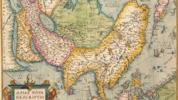
Nice example of Willem Blaeu's map of China, Tartary and Central Asia, extending from Mongolia to the Caspian and the Volga River, and to Tibet and the Upper Ganges River.
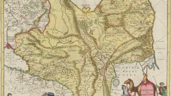
The map of Central and East Asia shows how mountainous the region is, as well as highlights many large lakes and towns. The tip of Korea is shown as a peninsula. Nova Zembla has an unfinished coastline and the Tartary Ocean is open and navigable. The Great Wall of China is shown in great detail, separating China from the rest of north-central Europe.
There are several notes across the map, adding extra information. Near the Great Wall, a note explains that the massive structure was meant to keep out the Tartars. The most distinct of these notes are just across the Great Wall in the Lop Desert. There, pairs of anthropomorphized animals dance—there is a deer couple, flying serpents, and a group of small bird-life creatures. A note explains that fantastical humans are said to inhabit this area and are led by a devilish figure.
The map also contains decorative elements. In the bottom left corner is a cherub dressed in European garb watching a turbaned man, meant to be an Asian, use dividers. They work atop the scale bar. In the lower right corner is an elaborate cartouche. The title in written on a camel’s blanket. A child rides the camel, which is led by men wearing supposedly Asian dress.