
map
-
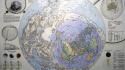
Map of the World: fake or not?
Ran into this depiction of our realm on the internet. Can't find the original source. Looks highly questinable, but who knows... Any ideas on what this is?- KorbenDallas
- Media item
- map
- Comments: 1
- Category: World
-

The Piri Reis Map of 1513
One of the most beautiful maps to survive the Great Age of Discoveries, the 1513 world map drawn by Ottoman admiral Piri Reis is also one of the most mysterious. Gregory McIntosh has uncovered new evidence in the map that shows it to be among the most important ever made. This detailed study...- KorbenDallas
- Resource
- 1513 map piri reis
- Category: Books
-
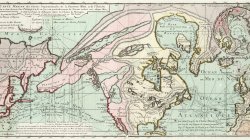
1752 map by Philippe Buache
Carte marine des parties septentrionales de la Grande Mer, et de l'ocean: Engraved colored in outline map of the northern Canada, Alaska and Arctic region Map of the northern Canada, Alaska and Arctic region showing glaciers, oceans and sea currents. and sea currents.- KorbenDallas
- Media item
- map
- Comments: 0
- Category: World
-

1595 - 1611 Orbis Geographica Mud Flood
World Map "Nova Totius Terrarum Orbis Geographica Ac Hydrographica Tabula a Pet Kaerio " Van Den Keere's hand colored decorative map of the World was first issued in 1608, it shows the then known regions of Europe, Africa, Asia, America and Terra Australis Incognita (Latin for "the unknown land...- KorbenDallas
- Media item
- map maps mud flood van den keere
- Comments: 0
- Category: UAP
-

1588 Ierusalem, et Suburbia eius, sicut Tempore Christi Floruit, cum Locis in quibus Christ Passus ... Descripta per Christianum Adrichom Delphum
Fine example of Braun & Hogenberg's 2-sheet map of Jerusalem, based upon Christian Van Adrichom's plan of ancient Jerusalem and its suburbs at the time of Jesus Christ. The plan was originally issued in Theatrum Terrae Sanctae" by Christian van Adrichom , 1533:1595 in 1584 in Koln, with a...- KorbenDallas
- Media item
- 1588 jerusalem map
- Comments: 0
- Category: Middle East
-
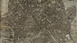
Plan of Ancient Rome
Plan of Ancient Rome- KorbenDallas
- Media item
- map plan rome
- Comments: 0
- Category: Europe
-

1650 Plan of Rome
1650 Plan of Rome- KorbenDallas
- Media item
- map plan rome
- Comments: 1
- Category: Europe
-
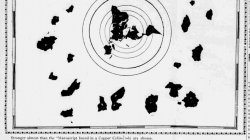
1,000 y.o. Map of the World. Published in 1907.
Stranger almost than the “Manuscript found in a Copper Cylinder” is the copy of a map which came across seas to Honolulu from a Buddhist Temple in the mountains of central Japan. It is a map of the world made 1000 years ago. Dr. Kobayashi, the well-known Japanese physician and surgeon of...- KorbenDallas
- Media item
- map world
- Comments: 2
- Category: World
-
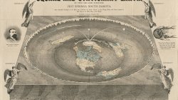
1893 Map of the Square and Stationary Earth
Map of the square and stationary earth. Four hundred passages in the Bible that condemn the Globe Theory, or the Flying Earth, and none sustain it. This map is the Bible map of the world. Creator: Orlando Ferguson- KorbenDallas
- Media item
- earth map
- Comments: 0
- Category: World
-
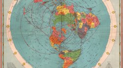
1944 CBS American School of the Air Age Map of the World
The American School of the Air was a half-hour educational radio program presented by CBS as a public affairs teaching supplement over an 18-year period during the 1930s and 1940s.- KorbenDallas
- Media item
- map world
- Comments: 0
- Category: World
-
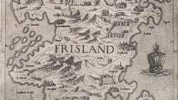
Old Map of Frisland
Frisland, also called Frischlant, Friesland, Frislandia, or Fixland, is a phantom island that appeared on virtually all of the maps of the North Atlantic from the 1560s through the 1660s.- KorbenDallas
- Media item
- map
- Comments: 0
- Category: Europe
-
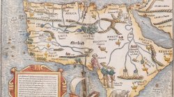
1542 Map of Africa
Totius Africae tabula et descriptio universalis etiam ultra Ptolemaei limites extensa. Map of the whole of Africa based on the Ptolematic source. 1542.- KorbenDallas
- Media item
- map
- Comments: 0
- Category: Africa
-
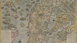
Carta Marina by Olaus Magnus published by Antony Lafreri in 1572
The Carta marina of the Swedish geographer and historian Olaus Magnus is one of the earliest accurate cartographic depictions of the Scandinavian peninsula. Drafted in Rome in 1539, by one of the more prominent Scandinavian Catholics in higher ecclesiastical service, it contains detail that is...- KorbenDallas
- Media item
- antony lafreri carta marina map olaus magnus
- Comments: 0
- Category: Europe
-
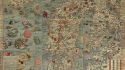
1527-39 Carta Marina by Olaus Magnus
Carta marina et descriptio septentrionalium terrarum is the first map of the Nordic countries to give details and place names, created by Swedish ecclesiastic Olaus Magnus and initially published in 1539. The map was created in Rome during 1527–39 by Olaus Magnus. To construct the map...- KorbenDallas
- Media item
- carta marina map olaus magnus
- Comments: 0
- Category: Europe
-
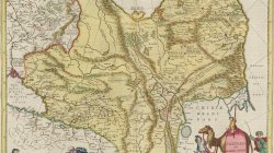
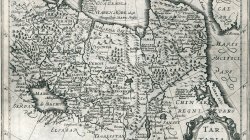
1665 Tartaria sive Magni Chami Imperivm Map
Nice example of Willem Blaeu's map of China, Tartary and Central Asia, extending from Mongolia to the Caspian and the Volga River, and to Tibet and the Upper Ganges River. The map of Central and East Asia shows how mountainous the region is, as well as highlights many large lakes and towns. The...- KorbenDallas
- Media item
- map tartaria tartary
- Comments: 0
- Category: Asia
-
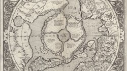
1595 Map of Hyperborea
This plate was originally published in 1595 in the posthumous part III of Mercator's Atlas.- KorbenDallas
- Media item
- hyperborea map
- Comments: 0
- Category: Arctic Region
-
1636 Map of Tartary
Copper engraved map of northern Asia from Moscow to the Anian Fretum, covers China, Korea and the northern Pacific coast of America showing the two continents separated by the Straits of Anian. Shows towns, villages, landmarks, mountains, and rivers.- KorbenDallas
- Media item
- map tartaria tartary
- Comments: 0
- Category: Asia
-
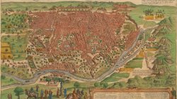
1572 City Plan of Cairo olim Babylon
Cairo is said to number 30,000 houses altogether. There are very many princely palaces and temples here, but also many hospices, schools and baths and large buildings containing the tombs of important persons. The streets contain such a throng of people, horses and mules that it is not possible...- KorbenDallas
- Media item
- map
- Comments: 0
- Category: Africa
-
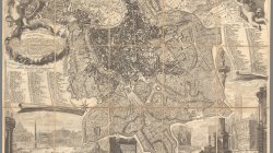
1773 City Plan of Rome
A later edition of Nolli's reduced copy of his large 12 sheet plan of Rome. In this 1773 edition, the author added the three new churches built since the 1748 plan, namely the church of San Paolo Primo Eremita, completed in 1785, the church of Santa Caterina da Siena, rebuilt between 1766 and...- KorbenDallas
- Media item
- map
- Comments: 0
- Category: Europe
-
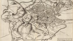
1557 City Plan of Rome
Engraved plan of Rome, engraved by N. Beatrizet for Antonio Lafreri in Rome. Author's initials in lower left corner: NB. The map depicts hills, the major monuments and shows the walls and fortifications constructed in Rome in 1556 and 1557, under the direction of Camillo Orsini during the reign...- KorbenDallas
- Media item
- map
- Comments: 0
- Category: Europe