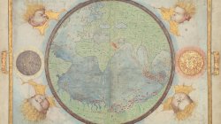
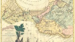
The map presented here is from the Miller Atlas in the collections of the National Library of France. Produced for King Manuel I of Portugal in 1519 by cartographers Pedro Reinel, his son Jorge Reinel, and Lopo Homem and miniaturist António de Holanda, the atlas contains eight maps on six loose sheets, painted on both sides. This map (folio 1 recto in the atlas) shows the Portuguese hemisphere; folio 1 verso is a title page with the coat of arms of Catherine de' Medicis. The text above the coat of arms reads: Hec est universi orbis ad hanc usqz diem cogniti tabula quam ego Lupus homo Cosmographus in clarissima Ulisipone civitate Anno domini nostri Millessimo quigentessimo decimo nono jussu Emanuelis incliti lusitanie Regis collatis pluribs aliis tam vetustorum qz recentiorum tabulis mag na industria et dilligenti labore depinxi (This is the map of the entire world known up to this day, which I myself, Lopo Homem the cartographer, drew with great skill and careful work in the very famous city of Lisbon in the year of our Lord 1519 under the rule of the honored Emanuel King of Lusitania, having collated many other maps both ancient and recent). The Treaty of Tordesillas in 1494 settled Spanish and Portuguese conflicts over newly discovered and undiscovered lands in the New World. The map shows only the territory allocated to Portugal. The atlas takes its name from Emmanuel Miller, who purchased it in 1855 from a bookseller in Santarém, Portugal. Miller's widow sold it to the National Library of France in 1897.