1770s: Seattle, Tsunami, Earthquakes, Lake Washington and Underwater Forests

I do not remember how the topic came up, but a while ago, a co-worker of mine mentioned some dude who was making a lot of money by illegally logging an underwater forest in Lake Washington.

Lake-Washington.jpg

From the legal perspective, the story ended up being a bit more complicated, but that's besides the point. Today, we are interested in the fact that at the bottom of lake Washington there are some "prehistoric" forests.

1904 map - lake washington.jpg
  • Three submerged forests rest at the bottom of Lake Washington.
  • About 1,100 years ago, an earthquake estimated to be 7.5 magnitude caused the trees to landslide into the lake.
  • The forests consist of several hundred trees, all firmly anchored in soil and either standing upright or tilted at a 45 degree angle.
  • When diver Leiter Hockett explored the trees off Holmes Point (just north of Kirkland) in 1958 he found himself “engulfed in a densely forested bottom.”
  • He was able to bring one tree to the surface, where the wood “although waterlogged [was] as sound and fresh as timber felled on Washington slopes today.”
  • What Lies Beneath – Secrets of Lake Washington


  • A Kirkland man has been convicted of felony theft and profiteering for illegally logging an underwater forest that slid into Lake Washington in an earthquake more than 1,000 years ago.
  • John J. Tortorelli was convicted by a King County Superior Court jury last week after a sixweek trial and four days of deliberation.
  • The trees are well-preserved, despite their age, because of the low oxygen content and low water temperature at the bottom of the lake, which separates Seattle from its eastern suburbs.
  • These trees were good timber. … They were sold for a substantial sum of money,” Senior Deputy Prosecutor Lynn Prunhuber told jurors in closing arguments.
  • The trees belong to the state, prosecutors said.
  • Tortorelli faces a maximum penalty of 10 years in prison, and prosecutors will ask that he be required to pay restitution for wood, valued at about $165,000. Sentencing will be scheduled next month.
  • Man Convicted Of Logging Ancient Underwater Forest Faces Maximum Of 10 Years
Lake Washington Sunken Forests
The Lake Washington sunken forests were both a part of the scientific discovery of a major fault line under Seattle, Washington, and part of a timber piracy case in the late 20th century. In a precedent-setting case, the Washington State Supreme Court decided that ancient drowned forests are state property and not eligible for salvage.
  • A major earthquake occurred on the Seattle Fault about 900 C.E., creating multiple forms of evidence that led to the discovery of the fault and its description in Science in 1992.
  • One of the forms of evidence was landslides at three locations around Lake Washington:
    • off the southeast corner of Mercer Island,
    • on the west side of the island across from Seattle's Seward Park,
    • and one near Saint Edward State Park in present-day Kirkland, Washington.
  • The landslides on heavily wooded land created "bizarre submerged forests" of old-growth timber, preserved by the cool water and low oxygen in the deep lake.
  • These sunken forests were known to early European settlers of the Seattle area, for whom the snags could be a hazard to ships on the lake, and as early as 1919, nearly 200 of the sunken trees had been removed from depths of 65–132 feet (20–40 m).
  • Radiocarbon dating and tree-ring dating of the wood in the late 20th century helped to establish the date of the earthquake.
  • Lake Washington sunken forests
  • The spooky, underwater forests of Lake Washington and Lake Sammamish
Science Magazine: 12/4/1992
It took me a few minutes to find the exact issue of the 1992 Science magazine mentioned in the Wikipedia article. Figured, their source would elaborate on certain things:
  • A major earthquake (magnitude 7 to 7.5) occurred on the Seattle Fault about 900 C.E., creating multiple forms of evidence.
  • One of the forms of evidence was landslides at three locations around Lake Washington.
  • Radiocarbon dating and tree-ring dating of the wood in the late 20th century helped to establish the date of the earthquake.
And, of course, the below statement from one of the above mentioned articles was also a motivator:
  • ...the wood “although waterlogged [was] as sound and fresh as timber felled on Washington slopes today.”
eq-10.jpg

KD: Needless to say I question any statements claiming the knowledge of any event that allegedly occurred "more than 1,000 years ago".
  • Radiocarbon dating and tree-ring dating of the wood in the late 20th century helped to establish the date of the earthquake.
Any form of radiocarbon dating requires the precise knowledge of atmospheric conditions existing at the time of an event. Today's atmospheric pressure is well known, but there are reasons to doubt that it has always been the same. The atmospheric composition we have today is this:
  • Nitrogen accounts for 78% of the atmosphere, oxygen 21% and argon 0.9%
  • Gases like carbon dioxide, nitrous oxides, methane, and ozone are trace gases that account for about a tenth of one percent of the atmosphere.
  • KD: Who knows what proportions we had some 300 years ago?
Are there reasonable doubts about the accuracy of the radiocarbon dating? There sure are plenty of those:


That said, let's take a look at some of the statements made by the authors of the article published by the Science Magazine in 1992.

eq-1.jpg

Land subsidence is a gradual settling or sudden sinking of the Earth’s surface. Subsidence - sinking of the ground because of underground material movement - is most often caused by the removal of water, oil, natural gas, or mineral resources out of the ground by pumping, fracking, or mining activities.
  • Subsidence can also be caused by natural events such as earthquakes, soil compaction, glacial isostatic adjustment, erosion, sinkhole formation, and adding water to fine soils deposited by wind (a natural process known as loess deposits).
eq-2.jpg

The below excerpt mentions the soil liquefaction: here is a video example.

eq-3.jpg

I have my own reasons to question this "less than 1,100 years ago" date. Older maps clearly demonstrate that there were events we are not allowed to know about.
eq-4.jpg

The below excerpt has nothing but some pseudo-scientific mumbo jumbo. Carbon-14 dating voodoo magic will always be a good tool to deliver disinformation to those who do not really care about the truth.

eq-5.jpg

Isn't it amazing that we have some indestructible, millennium-old fir logs lying around. Isn't it impressive that there are people out there know that one particular log was uprooted by a tsunami some 1,000 years ago?

eq-7.jpg

Our narrative compilers could be right about the mechanism of destruction, bar two little things:
  • 1. Dating
  • 2. Tsunamis and earthquakes are not always natural
eq-9.jpg

The below image was saved from the above posted video.

under-lake-wa.jpg

I have attached the PDF of this article. The web source of the article is here.

Lake Sammamish
Lake Sammamish is a freshwater lake 8 miles (13 km) east of Seattle. The lake is 7 miles (11 km) long and 1.5 miles (2 km) wide, with a maximum depth of 105 feet (32 m) and a surface area of 8 sq mi (21 sq km). It lies east of Lake Washington and west of the Sammamish Plateau, and stretches from Issaquah in the south to Redmond in the north. At Issaquah it is fed by Issaquah Creek, and at Redmond it drains to Lake Washington via the Sammamish River, named after the native people who once lived along its entire length.

lake sammamish.jpg

At the southern end of Lake Sammamish, just off Greenwood Point, several jagged, gray logs stick up from the water. They're the only visible sign of an ancient, perfectly-preserved underwater forest that's been sitting at the bottom of the lake for over a thousand years.
  • The story is a little scary. It starts with a massive earthquake that rattled the region around a thousand years ago - an earthquake so violent that some expanses of land were pushed 20 feet in the air and massive landslides occurred.
  • Source
The PTB want us to think that this log is a thousand years old. Right?
ls-log.jpg


KD: Our pseudo-scientific community is incapable to properly date anything. I do not think that this is necessarily their direct fault, because they exist within a set system of standards.
  • In this particular case, we are being offered an explanation of certain terrain features, with certain events being blamed.
  • Did these events happen 1,000 years ago, or did they happen 200-300 years ago?
  • Methinks, there is a huge consequential difference between these two dates.
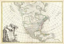
Take a look at these maps. From 1660s to about 1760-90s the North American continent looked like this. Why?
1792-map.jpg

What if events described in the Science Magazine article published in 1992 did not take place 1,000 years ago?


If it’s the same dude who participated in that 1992 studies, than their time line got a adjusted by quite a margin. They say 1700 now.

Of course, such a close date could not go unnoticed, and was hyped up by a narrative reciter.


May be we should question this 1700 date as well. Shouldn’t Lewis and Clark be more reliable? They were much closer to this devastating event.
str.jpg

If the Cascades could form in 1770s, what could prevent something similar from happening to the Grand Canyon area?


What else happened in 1770s?
 

Attachments

  • Pugetquake.pdf
    149.9 KB · Views: 2,030
Any form of radiocarbon dating requires the precise knowledge of atmospheric conditions existing at the time of an event. Today's atmospheric pressure is well known, but there are reasons to doubt that it has always been the same.
There are so many problems with carbon dating that anyone who accepts it uncritically literally has a religious belief. From very suspect calibration methods (look up "continuous tree-ring sequences") to wildly variant results:
Most concerning, though, is when the carbon dating directly opposes or contradicts other estimates. At this point, the carbon dating data is simply disregarded. It has been summed up most succinctly in the words of American neuroscience Professor Bruce Brew:

“If a C-14 date supports our theories, we put it in the main text. If it does not entirely contradict them, we put it in a footnote. And if it is completely out of date, we just drop it.”
And something I never really hear questioned either... how accurate is our measurement of the half-life of carbon anyway? "They" say it's about 5600 years, so we are in the sort of sample size territory that leads to highly speculative extrapolations (like climate change, population growth charts, etc, etc, etc).

Anyway, enough about that...


Of course, such a close date could not go unnoticed, and was hyped up by a narrative reciter.
Very interesting video. The Natives' account of the event especially:
In the year 1700, on Jan. 26 at 9 at night (Banta: The precision here from the professional storytellers is amazing.), in what is now Northern California, Earthquake was running up and down the coast. His feet were heavy, and when he ran, he shook the ground so much it sank down and the ocean poured in. “The earth would quake and quake again and quake again,” said the Yurok people. “And the water was flowing all over.” The people went to the top of a hill, wearing headbands of woodpecker feathers, so they could dance a jumping dance that would keep the earthquake away and return them to their normal lives. But then they looked down and saw the water covering their village and the whole coast; they knew they could never make the world right again.

That same night, farther up the coast in what is now Washington, Thunderbird and Whale had a terrible fight, making the mountains shake and uprooting the trees, said the Quileute and the Hoh people; they said the ocean rose up and covered the whole land. Farther north still, on Vancouver Island, dwarfs who lived in a mountain invited a person to dance around their drum; the person accidentally kicked the drum and got earthquake-foot, said the Nuu-chah-nulth people, and after that every step he took caused an earthquake. The land shook and the ocean flooded in, said the Huu-ay-aht people who are part of the Nuu-chah-nulth, and people didn’t even have time to wake up and get into their canoes, and “everything then drifted away, everything was lost and gone.”
Fanciful imaginations... except as it turned out, not so fanciful. Their story sort of reminded me of the account by the Ngangas on the activities of Jesuit father Dom Gongalo da Silveira. Silly superstitions or perhaps just a language barrier to describe unusual technology? Makes me wonder what "Thunderbird" and "Whale" represented... an aerial attack on a fleet?

The entire exploration history of the Pacific Northwest following the discovery of the New World is suspiciously sparse, in my opinion. As the story goes, after Balboa crossed the Isthmus of Panama in 1513, the Spanish lost interest for awhile in doing too much else in the Pacific (or as Balboa called it, in seeming defiance of his compass, the South Sea: "Most commonly it refers to the portion of the Pacific Ocean south of the equator. In 1513, when Spanish conquistador Vasco Núñez de Balboa coined the term Mar del Sur, or South Sea, the term was applied to the entire area of today's Pacific Ocean.")

I like the way this article describes it:
The Spanish were the first non-Natives to make a record of explorations along the Northwest Coast. Yet their approach to discovery of the territory was never very systematic. Spain approached the region somewhat defensively. It had colonized so successfully in South and Central America that it did not feel compelled to settle a place as remote as the Pacific Northwest. Moreover, in light of the fact that it had a very difficult time recruiting colonists to occupy a much closer shoreline—coastal California—actually getting Spaniards or mestizos to relocate in the Northwest would have been next to impossible. Yet for a couple of decades the Spanish felt it was important to make recorded voyages to the region, and claim it on behalf of the King of Spain, because they wanted to keep the region out of Russian and British hands. So after 1774 a series of voyages left Mexico, traveled northward, and scouted out the Northwest coast. Some expeditions undertook symbolic acts of possession on behalf of the Spanish king; others attempted to defend Spanish claims against European rivals; still others recorded scientific information about the region. By the mid-1790s, however, Spain had decided that in claiming the Northwest Coast it had overreached itself, and that the prudent course was to retrench to Alta California and Mexico (Cook 1973).
Seems pretty amazing that they would essentially punt the region (unless they were scared of running into giants if they went too far north) given the Spanish propensity for following rumors of "cities of gold" everywhere else. And wait, one of their boots on the ground did give this account:
The body of water separating Washington’s Olympic Peninsula from British Columbia’s Vancouver Island is called the Strait of Juan de Fuca. The name comes from a man who claimed, in 1592, to have been the first European to locate this passage. That the same man claimed not only that the lands through which the strait passed were “rich of gold, Silver, Pearle, and other things,” but also that he sailed out the far end of the strait into the Atlantic Ocean, of course cast doubt on this so-called discovery. De Fuca’s tale reminds us that Europeans had numerous ideas about the Pacific Northwest long before they actually set eyes on it. Whether factual or fanciful, these ideas shaped later experiences with the region.

The man named Juan de Fuca was really the Greek pilot Apóstolos Valerianos, who said he had been sailing on behalf of Spain. In 1596, in Venice, Valerianos told his tale to Michael Lok, an English merchant-adventurer. Lok passed the story along to other promoters of English overseas empire, who in turn published the story in 1625. Even more than the Spanish and French, the British were keenly interested in the prospect of a Northwest Passage, i.e. a waterway through the North American continent that would greatly expedite travel between Europe and East Asia. They therefore took a strong interest in Valerianos’s story, even though they also had a stake in refuting it in order to deny Spain’s claim to have arrived first on the Northwest Coast. In the later eighteenth century the English explorers James Cook and George Vancouver were clearly driven in part to find the Northwest Passage that Valerianos had described. When they did not find it, their priority became denigrating Spanish claims and promoting their own discoveries (see the selections below from George Vancouver).

Valerianos’s descriptions of the interior of the Strait of Juan de Fuca discredit the tale. Moreover, no other documents have turned up to corroborate the claim that he entered the Strait of Juan de Fuca in 1592. Yet certain details of Valerianos’s story—such as the names of certain sailors, a few maritime incidents, and some geographical details—do find support in the Spanish record of maritime activities off the coasts of Mexico. Moreover, if Juan de Fuca never entered the strait that bears his name, how did he know that it lay in the vicinity of the 47th and 48th parallels? Earlier scholars tended to see the Juan de Fuca story as almost entirely without basis (Wagner 1931 [Wagner 1931 is an accessible version and introduction to Valerianos’s account]). More recently, Warren L. Cook (1973:22-29), the foremost historian of Spanish expeditions to the Northwest Coast, has suggested that Valerianos may well have traveled to the vicinity of the strait. (Incidentally, the Spanish called the passage the Strait of Anián.)
So basically, de Fuca's account didn't jive with the geography of the area so later historians dismissed him (some even said he didn't exist). Will any of this be fully re-evaluated now, given that academia concedes a massive, possibly region changing earthquake in 1700? (I doubt it.)
Speaking of journals, that segues us back to Lewis and Clark. I've tried to locate in their journals the source of the claim that the Natives stated the Cascades were formed in an event which occurred 30 years prior to their arrival. I believe if it is anywhere, searching this site would reveal it:
I've used every search term combination I can think of with no luck so far. If anyone else would like to try their luck, please! I'm not giving up, in fact, the sections I've read are pretty interesting on their own, but it may take awhile to wade through all the material.
 
Wow dude appreciate the work you’ve put in here, looks like we’ve begun to uncover something someone out there may not be happy to bring into the light. Just a bit of warning on that... this could be an age old government insurance scam in regards to the colonial business that occurred shortly after.

On a side note I found it interesting that the west coast was supposedly home to the Seven Cities of Cibola and synonymously the Gold Rush...

3DFCD5FD-1DD7-4D24-B79C-D2C5D0F81B83.jpeg

 
Well, I'm not buying that trees that slid into a lake due to an earthquake that liquified the soil would be standing upright and firmly rooted in the soil. Also I'm not buying that trees that have been underwater for 1100 years would be "as sound and fresh as timber felled on Washington's slopes today".
My opinion based on the evidence is that that was probably a wooded valley that became flooded, whether by a lowering of the land or a rise in the water level, hard to say which. And not 1100 years ago.
 
This is indeed interesting:
  • The gaps in Lewis's writings are numerous and extensive.
  • In all, from May 1804 to September 1806, there are over four hundred days of missing entries by Lewis during the expedition proper.
  • Despite the quantity of the Lewis and Clark legacy in field notes, notebook journals, field journals, and scraps of diary writings, there persists a nagging question: Is the record complete? Duh?
  • The Missing Journals of Meriwether Lewis | Journals of the Lewis and Clark Expedition
@Banta, you were spot on.
 
In my humble opinion, Carbon 14 dating is not only a very inaccurate method of dating, but it is a tool of the control mechanism as well. I think that when a scientist requests a dating on an object using C14, somewhere a red flag appears and someone from the "New Narrative Bureau" is sent to oversee the operation and manipulate the results. As we have seen in various scientific journals C14 can give wildly various results even on the same object sample, with errors of even 1000 years. This method is wholly inaccurate and should not be used anymore.
Dendrochronology is a pretty accurate dating method that was also used by people in the old world. It works like this: "Timber core samples are sampled and used to measure the width of annual growth rings; by taking samples from different sites within a particular region, researchers can build a comprehensive historical sequence.". So comparing similar patterns in growth rings from different trees one can extend the timeline to thousands of years. This form of dating is especially useful to determine abnormal climate changes and other climate research.
Going back to the lakes of Seattle, those sunken trees would have probably shown a death date of around 300 years ago, but i am sure that data never saw the light of a scientific journal and has been tucked away. Those pine forests were probably around 5-600 years old so if there ever was an earthquake around 900 years ago that caused catastrophic flooding, it would certainly have showed up in the study of those dead lake trees. Simply comparing the sunken logs with very old tree samples from the Washington mountains would have given them the time of death of the lake forest.
To say that an earthquake is the cause of that disaster is like looking at a car collision and saying that the rear tire lost grip and caused the loss of control of the car. I have gone in more detail about what i think happened during the cataclysm that caused massive floods in the Bizzare transformations of North American maps article.
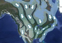
According to my geographical studies of various places around the world i have concluded that there was a massive shockwave that originated in the north and propagated all over the world dissipating in the south. This shockwave caused massive floods, earthquakes and shifted great bodies of water. I have found sediment evidence that the great West Sea existed between the two mountain chains of British Columbia. When this great lake was hit by the shockwave it spilled southward and westward. The sand and mud sediments from this ancient lake now cover Oregon, Idaho, Nevada, Arizona and California. The West Sea had 2 mouths (as we can see on this attached map of Robert Janvier from 1762) that spilled into the Pacific Ocean: the south mouth was where the city of Portland is now and the north mouth was where the town of Chilliwack is. Incidentally when Juan de Luca described his discovery of a passage to the Atlantic, he was in fact sailing west into the West Sea through the north mouth. He thought is was the Atlantic because it was due west. Obviously he did not have time to map the great lake during that voyage.
How the lakes of Seattle formed: when the shockwave hit and dislocated the great West Sea, it not only made massive floods through its two mouths, but also spilled through any mountain pass in the Cascade Range. The Seattle area was also hit by a massive spill from its north mouth and also water dislocated from the Salish Sea. The reason why the two lakes of Seattle have fresh water is because the majority of water that formed them came from an eastern spill (around where Lookout Mt, WA is) of the West Sea, which was probably a great fresh water lake remnant of an ancient glacier.
Everything the native tribes told in their stories is true: there was a great flood and earthquakes as well, but it happened approximately 300 years ago, not 900. The sedimentary evidence is all over the map and can be clearly seen on google earth. I have attached my North America flood cataclysm study as well.
What caused the massive showckwave that flooded the world? Who knows, we can only speculate. Possibly an asteroid or comet hit, possibly something else. until we will be allowed to do REAL science and geologycal/geographical studies, we can do our own.
Never stop questioning.

Map of North America - Robert Janvier - 1762.jpg North America - flood cataclysm study.jpg
 
1627405619820.jpg

A while back I read several of Graham Hancock's books and he thought a comet hit Canada and caused a massive flood in north America. He claimed as the flood ripped through eastern Washington state causing the scablands and dry falls, it deposited its contents near Spokane as a fertile soil palouse. He claimed the signature of a comet fit the evidence for reasons I forgot, and debunked the Missoula dam mainstream narrative. Some think comets could be chunks of the glass firmament breaking off. Now looking at the scablands I think ancient tree trunks. Interesting the massive map changes in 300 years. A tree growth ring study for the northwest would pinpoint a flood event.

1627406499868.jpg
 

Similar articles

Back
Top